You are here: Home > Network List > TA - USArray Transportable Network (new EarthScope stations) Stations List
> Station P17K Kvichak River, AK, USA > Earthquake Result Viewer
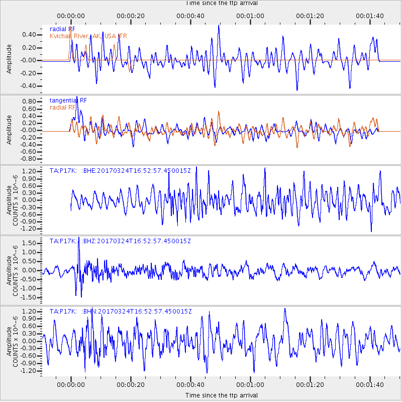
P17K Kvichak River, AK, USA - Earthquake Result Viewer
*The percent match for this event was below the threshold and hence no stack was calculated.
| Earthquake location: |
Ryukyu Islands, Japan |
| Earthquake latitude/longitude: |
26.9/127.2 |
| Earthquake time(UTC): |
2017/03/24 (083) 16:43:27 GMT |
| Earthquake Depth: |
77 km |
| Earthquake Magnitude: |
5.1 Mww |
| Earthquake Catalog/Contributor: |
NEIC PDE/us |
|
| Network: |
TA USArray Transportable Network (new EarthScope stations) |
| Station: |
P17K Kvichak River, AK, USA |
| Lat/Lon: |
59.20 N/156.44 W |
| Elevation: |
91 m |
|
| Distance: |
60.4 deg |
| Az: |
35.12 deg |
| Baz: |
273.343 deg |
| Ray Param: |
$rayparam |
*The percent match for this event was below the threshold and hence was not used in the summary stack. |
|
| Radial Match: |
54.87971 % |
| Radial Bump: |
400 |
| Transverse Match: |
55.646442 % |
| Transverse Bump: |
400 |
| SOD ConfigId: |
11737051 |
| Insert Time: |
2019-04-26 23:33:21.456 +0000 |
| GWidth: |
2.5 |
| Max Bumps: |
400 |
| Tol: |
0.001 |
|
Signal To Noise
| Channel | StoN | STA | LTA |
| TA:P17K: :BHZ:20170324T16:52:57.450015Z | 3.7847004 | 6.4192324E-7 | 1.6961006E-7 |
| TA:P17K: :BHN:20170324T16:52:57.450015Z | 1.05209 | 3.965346E-7 | 3.7690177E-7 |
| TA:P17K: :BHE:20170324T16:52:57.450015Z | 1.6399254 | 4.3603862E-7 | 2.658893E-7 |
| Arrivals |
| Ps | |
| PpPs | |
| PsPs/PpSs | |


