You are here: Home > Network List > TJ - Tajikistan National Seismic Network Stations List
> Station GARM Garm, Tajikistan > Earthquake Result Viewer
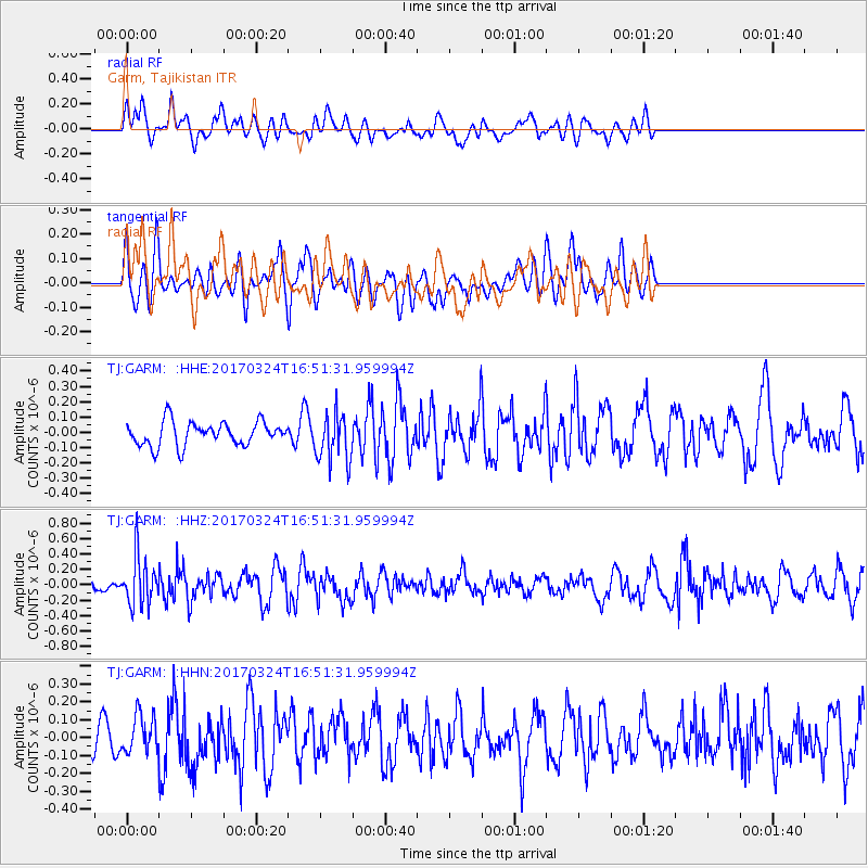
GARM Garm, Tajikistan - Earthquake Result Viewer
*The percent match for this event was below the threshold and hence no stack was calculated.
| Earthquake location: |
Ryukyu Islands, Japan |
| Earthquake latitude/longitude: |
26.9/127.2 |
| Earthquake time(UTC): |
2017/03/24 (083) 16:43:27 GMT |
| Earthquake Depth: |
77 km |
| Earthquake Magnitude: |
5.1 Mww |
| Earthquake Catalog/Contributor: |
NEIC PDE/us |
|
| Network: |
TJ Tajikistan National Seismic Network |
| Station: |
GARM Garm, Tajikistan |
| Lat/Lon: |
39.00 N/70.32 E |
| Elevation: |
1305 m |
|
| Distance: |
48.6 deg |
| Az: |
299.433 deg |
| Baz: |
86.561 deg |
| Ray Param: |
$rayparam |
*The percent match for this event was below the threshold and hence was not used in the summary stack. |
|
| Radial Match: |
40.16561 % |
| Radial Bump: |
400 |
| Transverse Match: |
53.723633 % |
| Transverse Bump: |
400 |
| SOD ConfigId: |
11737051 |
| Insert Time: |
2019-04-26 23:33:34.416 +0000 |
| GWidth: |
2.5 |
| Max Bumps: |
400 |
| Tol: |
0.001 |
|
Signal To Noise
| Channel | StoN | STA | LTA |
| TJ:GARM: :HHZ:20170324T16:51:31.959994Z | 3.8820007 | 3.0867E-7 | 7.9513114E-8 |
| TJ:GARM: :HHN:20170324T16:51:31.959994Z | 0.9234263 | 1.03927796E-7 | 1.1254585E-7 |
| TJ:GARM: :HHE:20170324T16:51:31.959994Z | 2.0180695 | 1.5752009E-7 | 7.805484E-8 |
| Arrivals |
| Ps | |
| PpPs | |
| PsPs/PpSs | |


