You are here: Home > Network List > CI - Caltech Regional Seismic Network Stations List
> Station HEC Hector, Baker, CA, USA > Earthquake Result Viewer
HEC Hector, Baker, CA, USA - Earthquake Result Viewer
| Earthquake location: |
Jujuy Province, Argentina |
| Earthquake latitude/longitude: |
-22.2/-65.8 |
| Earthquake time(UTC): |
2007/07/21 (202) 15:34:52 GMT |
| Earthquake Depth: |
290 km |
| Earthquake Magnitude: |
5.8 MB, 6.4 MW, 6.3 MW |
| Earthquake Catalog/Contributor: |
WHDF/NEIC |
|
| Network: |
CI Caltech Regional Seismic Network |
| Station: |
HEC Hector, Baker, CA, USA |
| Lat/Lon: |
34.83 N/116.33 W |
| Elevation: |
920 m |
|
| Distance: |
74.3 deg |
| Az: |
318.694 deg |
| Baz: |
131.938 deg |
| Ray Param: |
0.051648464 |
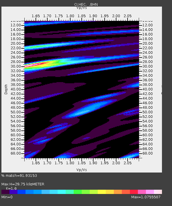
| Estimated Moho Depth: |
29.75 km |
| Estimated Crust Vp/Vs: |
1.60 |
| Assumed Crust Vp: |
6.276 km/s |
| Estimated Crust Vs: |
3.922 km/s |
| Estimated Crust Poisson's Ratio: |
0.18 |
|
| Radial Match: |
91.93153 % |
| Radial Bump: |
400 |
| Transverse Match: |
72.72295 % |
| Transverse Bump: |
400 |
| SOD ConfigId: |
2564 |
| Insert Time: |
2010-03-05 22:33:17.073 +0000 |
| GWidth: |
2.5 |
| Max Bumps: |
400 |
| Tol: |
0.001 |
|

Signal To Noise
| Channel | StoN | STA | LTA |
| CI:HEC: :BHN:20070721T15:45:27.204004Z | 1.883724 | 1.2439344E-7 | 6.6035916E-8 |
| CI:HEC: :BHE:20070721T15:45:27.204004Z | 1.7675619 | 1.2253815E-7 | 6.9326084E-8 |
| CI:HEC: :BHZ:20070721T15:45:27.204004Z | 8.419804 | 4.0715616E-7 | 4.8356966E-8 |
| Arrivals |
| Ps | 2.9 SECOND |
| PpPs | 12 SECOND |
| PsPs/PpSs | 15 SECOND |


