You are here: Home > Network List > GB - Great Britain Seismograph Network Stations List
> Station CWF CHARNWOOD FOREST, ENGLAND > Earthquake Result Viewer
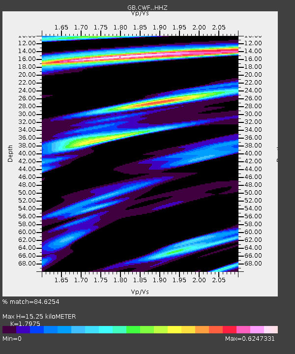
CWF CHARNWOOD FOREST, ENGLAND - Earthquake Result Viewer
| Earthquake location: |
Near Islands, Aleutian Islands |
| Earthquake latitude/longitude: |
52.8/172.2 |
| Earthquake time(UTC): |
2017/03/27 (086) 10:50:19 GMT |
| Earthquake Depth: |
10 km |
| Earthquake Magnitude: |
6.1 Mww |
| Earthquake Catalog/Contributor: |
NEIC PDE/us |
|
| Network: |
GB Great Britain Seismograph Network |
| Station: |
CWF CHARNWOOD FOREST, ENGLAND |
| Lat/Lon: |
52.74 N/1.31 W |
| Elevation: |
203 m |
|
| Distance: |
74.7 deg |
| Az: |
355.912 deg |
| Baz: |
4.082 deg |
| Ray Param: |
0.05216126 |
| Estimated Moho Depth: |
15.25 km |
| Estimated Crust Vp/Vs: |
1.80 |
| Assumed Crust Vp: |
6.276 km/s |
| Estimated Crust Vs: |
3.491 km/s |
| Estimated Crust Poisson's Ratio: |
0.28 |
|
| Radial Match: |
84.6254 % |
| Radial Bump: |
302 |
| Transverse Match: |
68.5676 % |
| Transverse Bump: |
378 |
| SOD ConfigId: |
11737051 |
| Insert Time: |
2019-04-26 23:49:00.347 +0000 |
| GWidth: |
2.5 |
| Max Bumps: |
400 |
| Tol: |
0.001 |
|

Signal To Noise
| Channel | StoN | STA | LTA |
| GB:CWF: :HHZ:20170327T11:01:27.650005Z | 8.7228775 | 2.0393845E-6 | 2.337972E-7 |
| GB:CWF: :HHN:20170327T11:01:27.650005Z | 4.3021827 | 8.410129E-7 | 1.9548517E-7 |
| GB:CWF: :HHE:20170327T11:01:27.650005Z | 0.7462381 | 1.669408E-7 | 2.2370982E-7 |
| Arrivals |
| Ps | 2.0 SECOND |
| PpPs | 6.6 SECOND |
| PsPs/PpSs | 8.6 SECOND |


