You are here: Home > Network List > GS - US Geological Survey Networks Stations List
> Station DEC09 Decatur Surface Seismic Site, Decatur, IL, USA > Earthquake Result Viewer
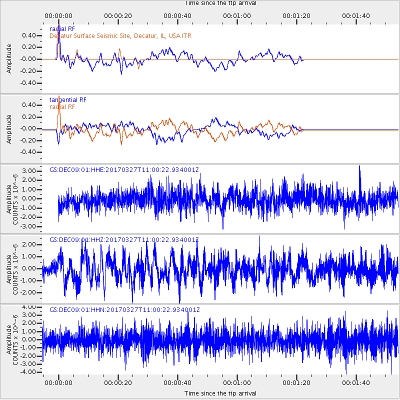
DEC09 Decatur Surface Seismic Site, Decatur, IL, USA - Earthquake Result Viewer
*The percent match for this event was below the threshold and hence no stack was calculated.
| Earthquake location: |
Near Islands, Aleutian Islands |
| Earthquake latitude/longitude: |
52.8/172.2 |
| Earthquake time(UTC): |
2017/03/27 (086) 10:50:19 GMT |
| Earthquake Depth: |
10 km |
| Earthquake Magnitude: |
6.1 Mww |
| Earthquake Catalog/Contributor: |
NEIC PDE/us |
|
| Network: |
GS US Geological Survey Networks |
| Station: |
DEC09 Decatur Surface Seismic Site, Decatur, IL, USA |
| Lat/Lon: |
39.87 N/88.92 W |
| Elevation: |
207 m |
|
| Distance: |
64.2 deg |
| Az: |
57.623 deg |
| Baz: |
318.213 deg |
| Ray Param: |
$rayparam |
*The percent match for this event was below the threshold and hence was not used in the summary stack. |
|
| Radial Match: |
60.815575 % |
| Radial Bump: |
400 |
| Transverse Match: |
52.065624 % |
| Transverse Bump: |
400 |
| SOD ConfigId: |
11737051 |
| Insert Time: |
2019-04-26 23:49:31.176 +0000 |
| GWidth: |
2.5 |
| Max Bumps: |
400 |
| Tol: |
0.001 |
|
Signal To Noise
| Channel | StoN | STA | LTA |
| GS:DEC09:01:HHZ:20170327T11:00:22.934001Z | 2.1028426 | 8.732033E-7 | 4.1524902E-7 |
| GS:DEC09:01:HHN:20170327T11:00:22.934001Z | 1.1714656 | 8.2241814E-7 | 7.0204203E-7 |
| GS:DEC09:01:HHE:20170327T11:00:22.934001Z | 1.6935744 | 1.1848452E-6 | 6.9961214E-7 |
| Arrivals |
| Ps | |
| PpPs | |
| PsPs/PpSs | |


