You are here: Home > Network List > IM - International Miscellaneous Stations Stations List
> Station TX32 Lajitas Array Site 32 (same as tx01 and TX00) > Earthquake Result Viewer
TX32 Lajitas Array Site 32 (same as tx01 and TX00) - Earthquake Result Viewer
| Earthquake location: |
Near Islands, Aleutian Islands |
| Earthquake latitude/longitude: |
52.8/172.2 |
| Earthquake time(UTC): |
2017/03/27 (086) 10:50:19 GMT |
| Earthquake Depth: |
10 km |
| Earthquake Magnitude: |
6.1 Mww |
| Earthquake Catalog/Contributor: |
NEIC PDE/us |
|
| Network: |
IM International Miscellaneous Stations |
| Station: |
TX32 Lajitas Array Site 32 (same as tx01 and TX00) |
| Lat/Lon: |
29.33 N/103.67 W |
| Elevation: |
996 m |
|
| Distance: |
63.8 deg |
| Az: |
75.475 deg |
| Baz: |
317.688 deg |
| Ray Param: |
0.059339 |
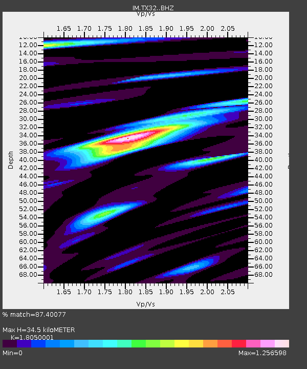
| Estimated Moho Depth: |
34.5 km |
| Estimated Crust Vp/Vs: |
1.81 |
| Assumed Crust Vp: |
6.419 km/s |
| Estimated Crust Vs: |
3.556 km/s |
| Estimated Crust Poisson's Ratio: |
0.28 |
|
| Radial Match: |
87.40077 % |
| Radial Bump: |
400 |
| Transverse Match: |
80.653854 % |
| Transverse Bump: |
400 |
| SOD ConfigId: |
11737051 |
| Insert Time: |
2019-04-26 23:50:00.903 +0000 |
| GWidth: |
2.5 |
| Max Bumps: |
400 |
| Tol: |
0.001 |
|

Signal To Noise
| Channel | StoN | STA | LTA |
| IM:TX32: :BHZ:20170327T11:00:20.348979Z | 14.019496 | 1.8931736E-6 | 1.3503863E-7 |
| IM:TX32: :BHN:20170327T11:00:20.348979Z | 2.4096117 | 3.299454E-7 | 1.3692888E-7 |
| IM:TX32: :BHE:20170327T11:00:20.348979Z | 2.6023645 | 5.5849443E-7 | 2.1461037E-7 |
| Arrivals |
| Ps | 4.5 SECOND |
| PpPs | 14 SECOND |
| PsPs/PpSs | 19 SECOND |


