You are here: Home > Network List > N4 - Central and EAstern US Network Stations List
> Station N33B J Bar K, Exeter, NE, USA > Earthquake Result Viewer
N33B J Bar K, Exeter, NE, USA - Earthquake Result Viewer
| Earthquake location: |
Near Islands, Aleutian Islands |
| Earthquake latitude/longitude: |
52.8/172.2 |
| Earthquake time(UTC): |
2017/03/27 (086) 10:50:19 GMT |
| Earthquake Depth: |
10 km |
| Earthquake Magnitude: |
6.1 Mww |
| Earthquake Catalog/Contributor: |
NEIC PDE/us |
|
| Network: |
N4 Central and EAstern US Network |
| Station: |
N33B J Bar K, Exeter, NE, USA |
| Lat/Lon: |
40.74 N/97.45 W |
| Elevation: |
482 m |
|
| Distance: |
59.1 deg |
| Az: |
62.331 deg |
| Baz: |
314.951 deg |
| Ray Param: |
0.062418878 |
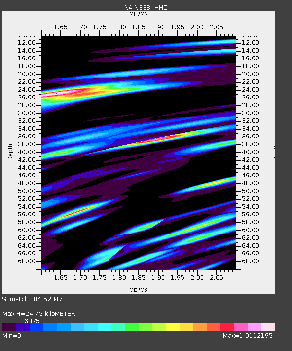
| Estimated Moho Depth: |
24.75 km |
| Estimated Crust Vp/Vs: |
1.64 |
| Assumed Crust Vp: |
6.498 km/s |
| Estimated Crust Vs: |
3.968 km/s |
| Estimated Crust Poisson's Ratio: |
0.20 |
|
| Radial Match: |
84.52847 % |
| Radial Bump: |
400 |
| Transverse Match: |
70.54808 % |
| Transverse Bump: |
400 |
| SOD ConfigId: |
11737051 |
| Insert Time: |
2019-04-26 23:52:13.639 +0000 |
| GWidth: |
2.5 |
| Max Bumps: |
400 |
| Tol: |
0.001 |
|

Signal To Noise
| Channel | StoN | STA | LTA |
| N4:N33B: :HHZ:20170327T10:59:48.550029Z | 3.7107205 | 7.965708E-7 | 2.1466742E-7 |
| N4:N33B: :HHN:20170327T10:59:48.550029Z | 2.7538457 | 4.5268996E-7 | 1.6438464E-7 |
| N4:N33B: :HHE:20170327T10:59:48.550029Z | 1.3578796 | 3.3905064E-7 | 2.4969125E-7 |
| Arrivals |
| Ps | 2.6 SECOND |
| PpPs | 9.5 SECOND |
| PsPs/PpSs | 12 SECOND |


