You are here: Home > Network List > TA - USArray Transportable Network (new EarthScope stations) Stations List
> Station KSCO Kaye Shedlock's, Cheyenne Wells, CO, USA > Earthquake Result Viewer
KSCO Kaye Shedlock's, Cheyenne Wells, CO, USA - Earthquake Result Viewer
| Earthquake location: |
Near Islands, Aleutian Islands |
| Earthquake latitude/longitude: |
52.8/172.2 |
| Earthquake time(UTC): |
2017/03/27 (086) 10:50:19 GMT |
| Earthquake Depth: |
10 km |
| Earthquake Magnitude: |
6.1 Mww |
| Earthquake Catalog/Contributor: |
NEIC PDE/us |
|
| Network: |
TA USArray Transportable Network (new EarthScope stations) |
| Station: |
KSCO Kaye Shedlock's, Cheyenne Wells, CO, USA |
| Lat/Lon: |
39.01 N/102.63 W |
| Elevation: |
1382 m |
|
| Distance: |
57.5 deg |
| Az: |
67.059 deg |
| Baz: |
314.132 deg |
| Ray Param: |
0.063478 |
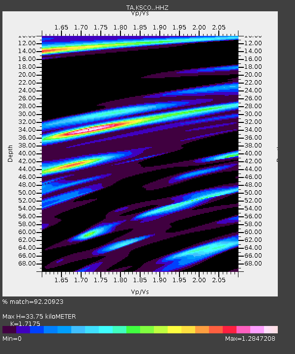
| Estimated Moho Depth: |
33.75 km |
| Estimated Crust Vp/Vs: |
1.72 |
| Assumed Crust Vp: |
6.242 km/s |
| Estimated Crust Vs: |
3.634 km/s |
| Estimated Crust Poisson's Ratio: |
0.24 |
|
| Radial Match: |
92.20923 % |
| Radial Bump: |
285 |
| Transverse Match: |
64.81359 % |
| Transverse Bump: |
353 |
| SOD ConfigId: |
11737051 |
| Insert Time: |
2019-04-26 23:55:54.375 +0000 |
| GWidth: |
2.5 |
| Max Bumps: |
400 |
| Tol: |
0.001 |
|

Signal To Noise
| Channel | StoN | STA | LTA |
| TA:KSCO: :HHZ:20170327T10:59:37.160015Z | 8.056138 | 9.405897E-7 | 1.1675442E-7 |
| TA:KSCO: :HHN:20170327T10:59:37.160015Z | 0.9463082 | 2.575115E-7 | 2.721222E-7 |
| TA:KSCO: :HHE:20170327T10:59:37.160015Z | 1.6177771 | 4.6959542E-7 | 2.9027203E-7 |
| Arrivals |
| Ps | 4.1 SECOND |
| PpPs | 14 SECOND |
| PsPs/PpSs | 18 SECOND |


