You are here: Home > Network List > TA - USArray Transportable Network (new EarthScope stations) Stations List
> Station MDND Maddock, ND, USA > Earthquake Result Viewer
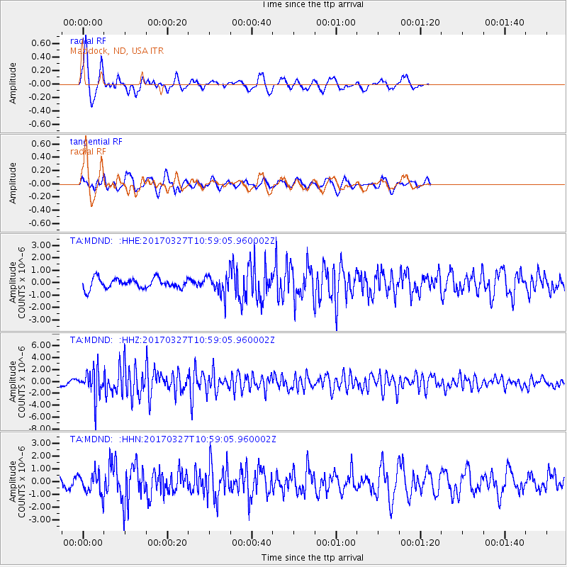
MDND Maddock, ND, USA - Earthquake Result Viewer
*The percent match for this event was below the threshold and hence no stack was calculated.
| Earthquake location: |
Near Islands, Aleutian Islands |
| Earthquake latitude/longitude: |
52.8/172.2 |
| Earthquake time(UTC): |
2017/03/27 (086) 10:50:19 GMT |
| Earthquake Depth: |
10 km |
| Earthquake Magnitude: |
6.1 Mww |
| Earthquake Catalog/Contributor: |
NEIC PDE/us |
|
| Network: |
TA USArray Transportable Network (new EarthScope stations) |
| Station: |
MDND Maddock, ND, USA |
| Lat/Lon: |
47.85 N/99.60 W |
| Elevation: |
479 m |
|
| Distance: |
53.1 deg |
| Az: |
57.315 deg |
| Baz: |
310.648 deg |
| Ray Param: |
$rayparam |
*The percent match for this event was below the threshold and hence was not used in the summary stack. |
|
| Radial Match: |
72.825005 % |
| Radial Bump: |
377 |
| Transverse Match: |
63.97732 % |
| Transverse Bump: |
361 |
| SOD ConfigId: |
11737051 |
| Insert Time: |
2019-04-26 23:56:00.124 +0000 |
| GWidth: |
2.5 |
| Max Bumps: |
400 |
| Tol: |
0.001 |
|
Signal To Noise
| Channel | StoN | STA | LTA |
| TA:MDND: :HHZ:20170327T10:59:05.960002Z | 7.8105936 | 2.4141145E-6 | 3.0908208E-7 |
| TA:MDND: :HHN:20170327T10:59:05.960002Z | 2.0081174 | 7.8650055E-7 | 3.9166065E-7 |
| TA:MDND: :HHE:20170327T10:59:05.960002Z | 2.0091271 | 8.044652E-7 | 4.0040533E-7 |
| Arrivals |
| Ps | |
| PpPs | |
| PsPs/PpSs | |


