You are here: Home > Network List > TA - USArray Transportable Network (new EarthScope stations) Stations List
> Station SFIN Lafayette, IN, USA > Earthquake Result Viewer
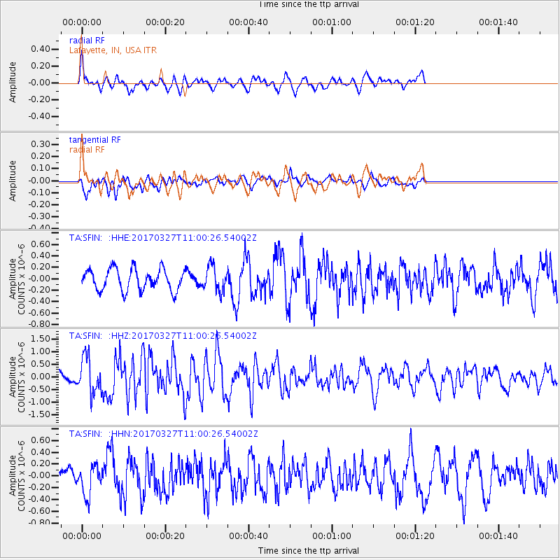
SFIN Lafayette, IN, USA - Earthquake Result Viewer
*The percent match for this event was below the threshold and hence no stack was calculated.
| Earthquake location: |
Near Islands, Aleutian Islands |
| Earthquake latitude/longitude: |
52.8/172.2 |
| Earthquake time(UTC): |
2017/03/27 (086) 10:50:19 GMT |
| Earthquake Depth: |
10 km |
| Earthquake Magnitude: |
6.1 Mww |
| Earthquake Catalog/Contributor: |
NEIC PDE/us |
|
| Network: |
TA USArray Transportable Network (new EarthScope stations) |
| Station: |
SFIN Lafayette, IN, USA |
| Lat/Lon: |
40.38 N/87.10 W |
| Elevation: |
165 m |
|
| Distance: |
64.7 deg |
| Az: |
56.091 deg |
| Baz: |
318.725 deg |
| Ray Param: |
$rayparam |
*The percent match for this event was below the threshold and hence was not used in the summary stack. |
|
| Radial Match: |
74.12174 % |
| Radial Bump: |
400 |
| Transverse Match: |
58.6016 % |
| Transverse Bump: |
400 |
| SOD ConfigId: |
11737051 |
| Insert Time: |
2019-04-26 23:56:06.974 +0000 |
| GWidth: |
2.5 |
| Max Bumps: |
400 |
| Tol: |
0.001 |
|
Signal To Noise
| Channel | StoN | STA | LTA |
| TA:SFIN: :HHZ:20170327T11:00:26.54002Z | 2.9294558 | 7.0426955E-7 | 2.4040972E-7 |
| TA:SFIN: :HHN:20170327T11:00:26.54002Z | 1.1707345 | 2.6303758E-7 | 2.246774E-7 |
| TA:SFIN: :HHE:20170327T11:00:26.54002Z | 1.1686648 | 2.1625495E-7 | 1.8504446E-7 |
| Arrivals |
| Ps | |
| PpPs | |
| PsPs/PpSs | |


