You are here: Home > Network List > TA - USArray Transportable Network (new EarthScope stations) Stations List
> Station V35K Ketchikan, AK, USA > Earthquake Result Viewer
V35K Ketchikan, AK, USA - Earthquake Result Viewer
| Earthquake location: |
Near Islands, Aleutian Islands |
| Earthquake latitude/longitude: |
52.8/172.2 |
| Earthquake time(UTC): |
2017/03/27 (086) 10:50:19 GMT |
| Earthquake Depth: |
10 km |
| Earthquake Magnitude: |
6.1 Mww |
| Earthquake Catalog/Contributor: |
NEIC PDE/us |
|
| Network: |
TA USArray Transportable Network (new EarthScope stations) |
| Station: |
V35K Ketchikan, AK, USA |
| Lat/Lon: |
55.33 N/131.62 W |
| Elevation: |
64 m |
|
| Distance: |
32.3 deg |
| Az: |
62.648 deg |
| Baz: |
289.308 deg |
| Ray Param: |
0.07870439 |
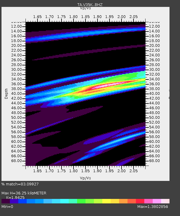
| Estimated Moho Depth: |
36.25 km |
| Estimated Crust Vp/Vs: |
1.94 |
| Assumed Crust Vp: |
6.545 km/s |
| Estimated Crust Vs: |
3.37 km/s |
| Estimated Crust Poisson's Ratio: |
0.32 |
|
| Radial Match: |
83.09927 % |
| Radial Bump: |
394 |
| Transverse Match: |
69.979126 % |
| Transverse Bump: |
400 |
| SOD ConfigId: |
11737051 |
| Insert Time: |
2019-04-26 23:56:13.057 +0000 |
| GWidth: |
2.5 |
| Max Bumps: |
400 |
| Tol: |
0.001 |
|
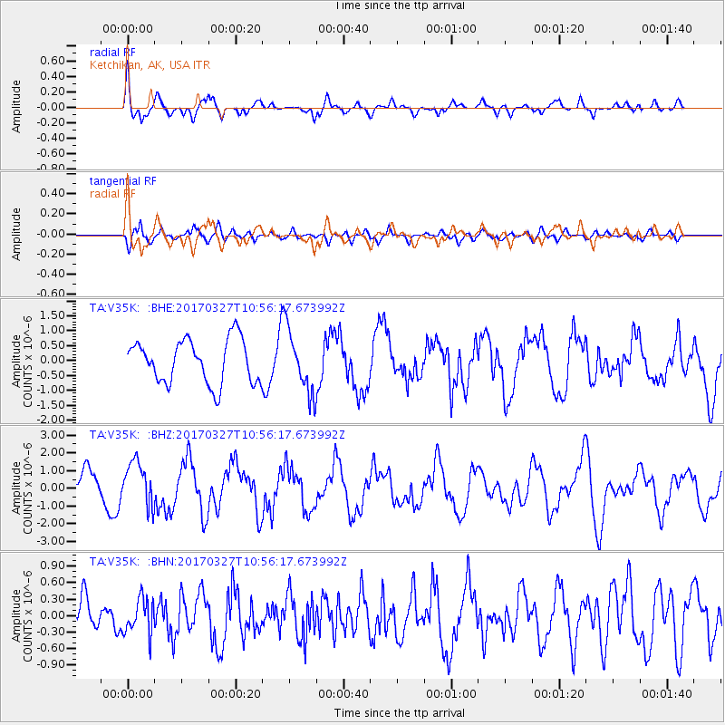
Signal To Noise
| Channel | StoN | STA | LTA |
| TA:V35K: :BHZ:20170327T10:56:17.673992Z | 1.5683722 | 1.2574471E-6 | 8.01753E-7 |
| TA:V35K: :BHN:20170327T10:56:17.673992Z | 0.837777 | 3.1944052E-7 | 3.812954E-7 |
| TA:V35K: :BHE:20170327T10:56:17.673992Z | 1.4367534 | 1.0521329E-6 | 7.322989E-7 |
| Arrivals |
| Ps | 5.6 SECOND |
| PpPs | 15 SECOND |
| PsPs/PpSs | 21 SECOND |


