You are here: Home > Network List > UW - Pacific Northwest Regional Seismic Network Stations List
> Station FISH Seaside, OR, USA > Earthquake Result Viewer
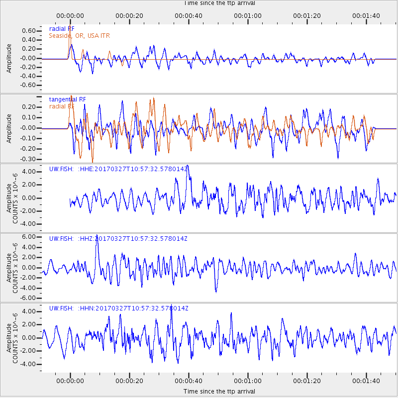
FISH Seaside, OR, USA - Earthquake Result Viewer
*The percent match for this event was below the threshold and hence no stack was calculated.
| Earthquake location: |
Near Islands, Aleutian Islands |
| Earthquake latitude/longitude: |
52.8/172.2 |
| Earthquake time(UTC): |
2017/03/27 (086) 10:50:19 GMT |
| Earthquake Depth: |
10 km |
| Earthquake Magnitude: |
6.1 Mww |
| Earthquake Catalog/Contributor: |
NEIC PDE/us |
|
| Network: |
UW Pacific Northwest Regional Seismic Network |
| Station: |
FISH Seaside, OR, USA |
| Lat/Lon: |
45.93 N/123.56 W |
| Elevation: |
325 m |
|
| Distance: |
41.1 deg |
| Az: |
72.86 deg |
| Baz: |
303.761 deg |
| Ray Param: |
$rayparam |
*The percent match for this event was below the threshold and hence was not used in the summary stack. |
|
| Radial Match: |
74.9526 % |
| Radial Bump: |
400 |
| Transverse Match: |
57.61853 % |
| Transverse Bump: |
400 |
| SOD ConfigId: |
11737051 |
| Insert Time: |
2019-04-26 23:57:07.269 +0000 |
| GWidth: |
2.5 |
| Max Bumps: |
400 |
| Tol: |
0.001 |
|
Signal To Noise
| Channel | StoN | STA | LTA |
| UW:FISH: :HHZ:20170327T10:57:32.578014Z | 0.92862505 | 6.439389E-7 | 6.9343264E-7 |
| UW:FISH: :HHN:20170327T10:57:32.578014Z | 1.3665001 | 1.1437522E-6 | 8.369938E-7 |
| UW:FISH: :HHE:20170327T10:57:32.578014Z | 1.0553027 | 9.148061E-7 | 8.66866E-7 |
| Arrivals |
| Ps | |
| PpPs | |
| PsPs/PpSs | |


