You are here: Home > Network List > TA - USArray Transportable Network (new EarthScope stations) Stations List
> Station A21K Barrow, AK, USA > Earthquake Result Viewer
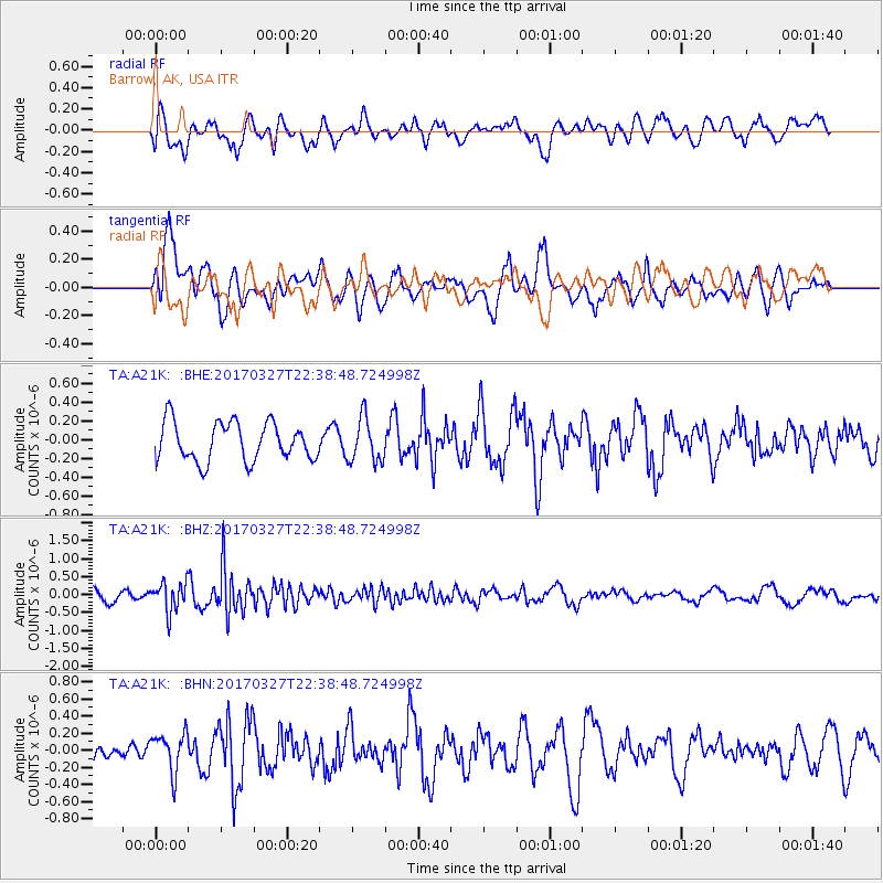
A21K Barrow, AK, USA - Earthquake Result Viewer
*The percent match for this event was below the threshold and hence no stack was calculated.
| Earthquake location: |
Eastern Sea Of Japan |
| Earthquake latitude/longitude: |
42.1/138.5 |
| Earthquake time(UTC): |
2017/03/27 (086) 22:31:21 GMT |
| Earthquake Depth: |
10 km |
| Earthquake Magnitude: |
5.1 Mww |
| Earthquake Catalog/Contributor: |
NEIC PDE/us |
|
| Network: |
TA USArray Transportable Network (new EarthScope stations) |
| Station: |
A21K Barrow, AK, USA |
| Lat/Lon: |
71.32 N/156.62 W |
| Elevation: |
577 m |
|
| Distance: |
42.8 deg |
| Az: |
25.419 deg |
| Baz: |
262.835 deg |
| Ray Param: |
$rayparam |
*The percent match for this event was below the threshold and hence was not used in the summary stack. |
|
| Radial Match: |
60.15666 % |
| Radial Bump: |
400 |
| Transverse Match: |
76.16225 % |
| Transverse Bump: |
400 |
| SOD ConfigId: |
11737051 |
| Insert Time: |
2019-04-27 00:05:43.378 +0000 |
| GWidth: |
2.5 |
| Max Bumps: |
400 |
| Tol: |
0.001 |
|
Signal To Noise
| Channel | StoN | STA | LTA |
| TA:A21K: :BHZ:20170327T22:38:48.724998Z | 2.6243382 | 4.084744E-7 | 1.5564854E-7 |
| TA:A21K: :BHN:20170327T22:38:48.724998Z | 1.7059727 | 2.3077745E-7 | 1.3527617E-7 |
| TA:A21K: :BHE:20170327T22:38:48.724998Z | 1.1532266 | 2.3652598E-7 | 2.050993E-7 |
| Arrivals |
| Ps | |
| PpPs | |
| PsPs/PpSs | |


