You are here: Home > Network List > II - Global Seismograph Network (GSN - IRIS/IDA) Stations List
> Station NIL Nilore, Pakistan > Earthquake Result Viewer
NIL Nilore, Pakistan - Earthquake Result Viewer
| Earthquake location: |
Solomon Islands |
| Earthquake latitude/longitude: |
-8.9/158.4 |
| Earthquake time(UTC): |
2015/11/18 (322) 18:31:04 GMT |
| Earthquake Depth: |
11 km |
| Earthquake Magnitude: |
6.8 MWB, 7.0 MI |
| Earthquake Catalog/Contributor: |
NEIC PDE/NEIC COMCAT |
|
| Network: |
II Global Seismograph Network (GSN - IRIS/IDA) |
| Station: |
NIL Nilore, Pakistan |
| Lat/Lon: |
33.65 N/73.27 E |
| Elevation: |
629 m |
|
| Distance: |
90.9 deg |
| Az: |
303.772 deg |
| Baz: |
100.075 deg |
| Ray Param: |
0.041640904 |
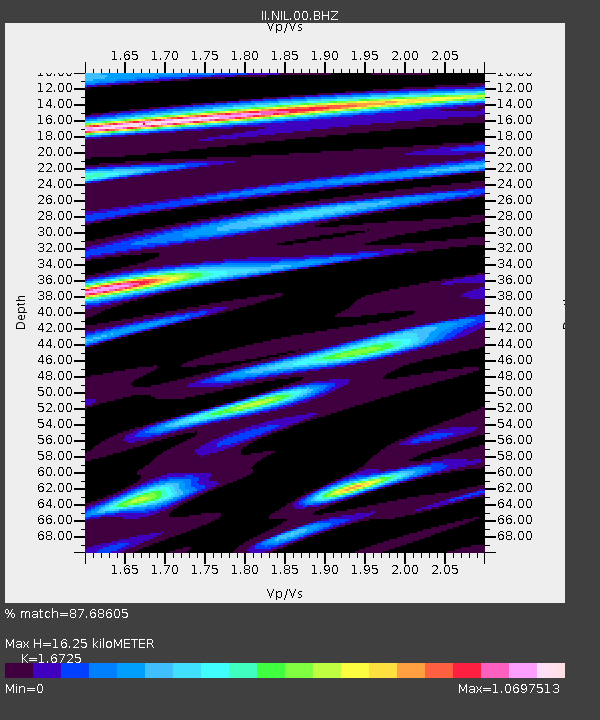
| Estimated Moho Depth: |
16.25 km |
| Estimated Crust Vp/Vs: |
1.67 |
| Assumed Crust Vp: |
6.242 km/s |
| Estimated Crust Vs: |
3.732 km/s |
| Estimated Crust Poisson's Ratio: |
0.22 |
|
| Radial Match: |
87.68605 % |
| Radial Bump: |
400 |
| Transverse Match: |
80.1263 % |
| Transverse Bump: |
400 |
| SOD ConfigId: |
1259291 |
| Insert Time: |
2015-12-02 19:17:07.653 +0000 |
| GWidth: |
2.5 |
| Max Bumps: |
400 |
| Tol: |
0.001 |
|

Signal To Noise
| Channel | StoN | STA | LTA |
| II:NIL:00:BHZ:20151118T18:43:36.318972Z | 2.586379 | 4.5765088E-7 | 1.7694656E-7 |
| II:NIL:00:BH1:20151118T18:43:36.318972Z | 0.71667004 | 8.4087766E-8 | 1.1733121E-7 |
| II:NIL:00:BH2:20151118T18:43:36.318972Z | 2.2879395 | 1.4512422E-7 | 6.343009E-8 |
| Arrivals |
| Ps | 1.8 SECOND |
| PpPs | 6.8 SECOND |
| PsPs/PpSs | 8.6 SECOND |


