You are here: Home > Network List > AE - Arizona Broadband Seismic Network Stations List
> Station Y14A Wickenburg, AZ, USA > Earthquake Result Viewer
Y14A Wickenburg, AZ, USA - Earthquake Result Viewer
| Earthquake location: |
Near East Coast Of Kamchatka |
| Earthquake latitude/longitude: |
56.9/162.7 |
| Earthquake time(UTC): |
2017/03/29 (088) 04:09:24 GMT |
| Earthquake Depth: |
23 km |
| Earthquake Magnitude: |
6.6 Mww |
| Earthquake Catalog/Contributor: |
NEIC PDE/us |
|
| Network: |
AE Arizona Broadband Seismic Network |
| Station: |
Y14A Wickenburg, AZ, USA |
| Lat/Lon: |
33.94 N/113.00 W |
| Elevation: |
731 m |
|
| Distance: |
59.3 deg |
| Az: |
74.126 deg |
| Baz: |
320.621 deg |
| Ray Param: |
0.062238257 |
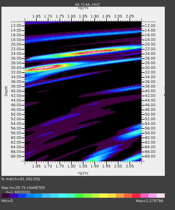
| Estimated Moho Depth: |
29.75 km |
| Estimated Crust Vp/Vs: |
1.68 |
| Assumed Crust Vp: |
6.264 km/s |
| Estimated Crust Vs: |
3.728 km/s |
| Estimated Crust Poisson's Ratio: |
0.23 |
|
| Radial Match: |
91.081055 % |
| Radial Bump: |
340 |
| Transverse Match: |
67.022 % |
| Transverse Bump: |
400 |
| SOD ConfigId: |
11737051 |
| Insert Time: |
2019-04-27 00:17:11.036 +0000 |
| GWidth: |
2.5 |
| Max Bumps: |
400 |
| Tol: |
0.001 |
|

Signal To Noise
| Channel | StoN | STA | LTA |
| AE:Y14A: :HHZ:20170329T04:18:53.699995Z | 15.463882 | 1.5423866E-6 | 9.974123E-8 |
| AE:Y14A: :HHN:20170329T04:18:53.699995Z | 8.123037 | 1.2002782E-6 | 1.4776224E-7 |
| AE:Y14A: :HHE:20170329T04:18:53.699995Z | 7.947055 | 1.0425057E-6 | 1.311814E-7 |
| Arrivals |
| Ps | 3.4 SECOND |
| PpPs | 12 SECOND |
| PsPs/PpSs | 16 SECOND |


