You are here: Home > Network List > TA - USArray Transportable Network (new EarthScope stations) Stations List
> Station F04A Amboy, WA, USA > Earthquake Result Viewer
F04A Amboy, WA, USA - Earthquake Result Viewer

| Earthquake location: |
Solomon Islands |
| Earthquake latitude/longitude: |
-7.3/155.7 |
| Earthquake time(UTC): |
2007/04/01 (091) 21:11:33 GMT |
| Earthquake Depth: |
10 km |
| Earthquake Magnitude: |
6.3 MB |
| Earthquake Catalog/Contributor: |
WHDF/NEIC |
|
| Network: |
TA USArray Transportable Network (new EarthScope stations) |
| Station: |
F04A Amboy, WA, USA |
| Lat/Lon: |
45.93 N/122.42 W |
| Elevation: |
211 m |
|
| Distance: |
89.6 deg |
| Az: |
43.699 deg |
| Baz: |
259.105 deg |
| Ray Param: |
0.04176594 |
| Estimated Moho Depth: |
12.75 km |
| Estimated Crust Vp/Vs: |
1.61 |
| Assumed Crust Vp: |
6.566 km/s |
| Estimated Crust Vs: |
4.091 km/s |
| Estimated Crust Poisson's Ratio: |
0.18 |
|
| Radial Match: |
94.21497 % |
| Radial Bump: |
356 |
| Transverse Match: |
73.06417 % |
| Transverse Bump: |
400 |
| SOD ConfigId: |
2564 |
| Insert Time: |
2010-03-05 22:38:45.338 +0000 |
| GWidth: |
2.5 |
| Max Bumps: |
400 |
| Tol: |
0.001 |
|
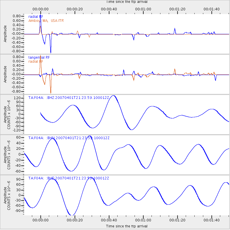
Signal To Noise
| Channel | StoN | STA | LTA |
| TA:F04A: :BHN:20070401T21:23:59.100012Z | 0.96876717 | 2.7232674E-5 | 2.8110648E-5 |
| TA:F04A: :BHE:20070401T21:23:59.100012Z | 1.5303271 | 5.8696252E-5 | 3.8355363E-5 |
| TA:F04A: :BHZ:20070401T21:23:59.100012Z | 1.9843167 | 8.903152E-5 | 4.4867593E-5 |
| Arrivals |
| Ps | 1.2 SECOND |
| PpPs | 4.9 SECOND |
| PsPs/PpSs | 6.1 SECOND |


