You are here: Home > Network List > IU - Global Seismograph Network (GSN - IRIS/USGS) Stations List
> Station POHA Pohakuloa, Hawaii, USA > Earthquake Result Viewer
POHA Pohakuloa, Hawaii, USA - Earthquake Result Viewer
| Earthquake location: |
Solomon Islands |
| Earthquake latitude/longitude: |
-8.9/158.4 |
| Earthquake time(UTC): |
2015/11/18 (322) 18:31:04 GMT |
| Earthquake Depth: |
11 km |
| Earthquake Magnitude: |
6.8 MWB, 7.0 MI |
| Earthquake Catalog/Contributor: |
NEIC PDE/NEIC COMCAT |
|
| Network: |
IU Global Seismograph Network (GSN - IRIS/USGS) |
| Station: |
POHA Pohakuloa, Hawaii, USA |
| Lat/Lon: |
19.76 N/155.53 W |
| Elevation: |
1990 m |
|
| Distance: |
53.6 deg |
| Az: |
57.438 deg |
| Baz: |
242.142 deg |
| Ray Param: |
0.06601465 |
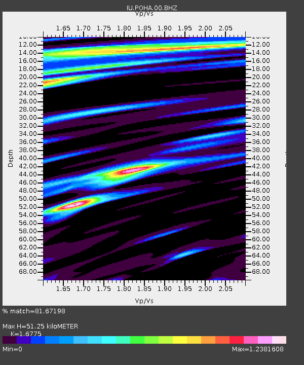
| Estimated Moho Depth: |
51.25 km |
| Estimated Crust Vp/Vs: |
1.68 |
| Assumed Crust Vp: |
5.195 km/s |
| Estimated Crust Vs: |
3.097 km/s |
| Estimated Crust Poisson's Ratio: |
0.22 |
|
| Radial Match: |
81.67198 % |
| Radial Bump: |
400 |
| Transverse Match: |
66.10009 % |
| Transverse Bump: |
400 |
| SOD ConfigId: |
1259291 |
| Insert Time: |
2015-12-02 19:17:46.173 +0000 |
| GWidth: |
2.5 |
| Max Bumps: |
400 |
| Tol: |
0.001 |
|
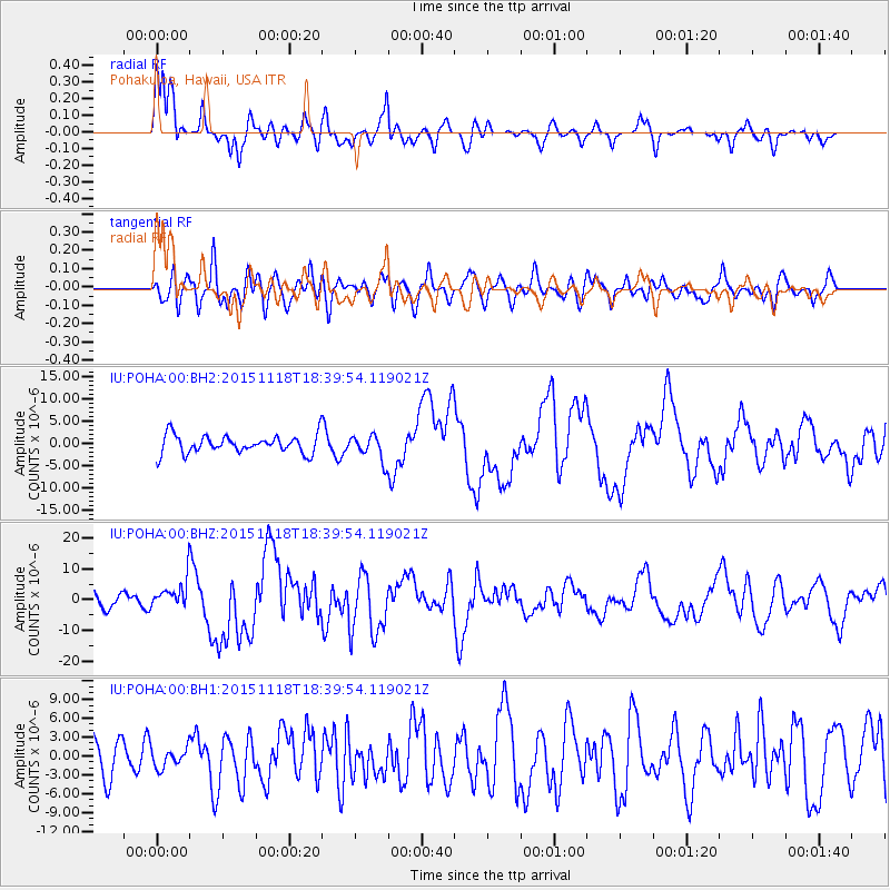
Signal To Noise
| Channel | StoN | STA | LTA |
| IU:POHA:00:BHZ:20151118T18:39:54.119021Z | 2.5752118 | 4.631982E-6 | 1.79868E-6 |
| IU:POHA:00:BH1:20151118T18:39:54.119021Z | 0.5996487 | 1.5354407E-6 | 2.560567E-6 |
| IU:POHA:00:BH2:20151118T18:39:54.119021Z | 1.3619289 | 2.7869335E-6 | 2.0463135E-6 |
| Arrivals |
| Ps | 6.9 SECOND |
| PpPs | 25 SECOND |
| PsPs/PpSs | 32 SECOND |


