You are here: Home > Network List > CI - Caltech Regional Seismic Network Stations List
> Station ADO Adelanto Receiving Station, Victorville, CA, USA > Earthquake Result Viewer
ADO Adelanto Receiving Station, Victorville, CA, USA - Earthquake Result Viewer

| Earthquake location: |
Near East Coast Of Kamchatka |
| Earthquake latitude/longitude: |
56.9/162.7 |
| Earthquake time(UTC): |
2017/03/29 (088) 04:09:24 GMT |
| Earthquake Depth: |
23 km |
| Earthquake Magnitude: |
6.6 Mww |
| Earthquake Catalog/Contributor: |
NEIC PDE/us |
|
| Network: |
CI Caltech Regional Seismic Network |
| Station: |
ADO Adelanto Receiving Station, Victorville, CA, USA |
| Lat/Lon: |
34.55 N/117.43 W |
| Elevation: |
908 m |
|
| Distance: |
56.5 deg |
| Az: |
76.989 deg |
| Baz: |
319.66 deg |
| Ray Param: |
0.064073086 |
| Estimated Moho Depth: |
28.25 km |
| Estimated Crust Vp/Vs: |
1.99 |
| Assumed Crust Vp: |
6.276 km/s |
| Estimated Crust Vs: |
3.154 km/s |
| Estimated Crust Poisson's Ratio: |
0.33 |
|
| Radial Match: |
92.06055 % |
| Radial Bump: |
380 |
| Transverse Match: |
85.32191 % |
| Transverse Bump: |
369 |
| SOD ConfigId: |
11737051 |
| Insert Time: |
2019-04-27 00:18:21.003 +0000 |
| GWidth: |
2.5 |
| Max Bumps: |
400 |
| Tol: |
0.001 |
|
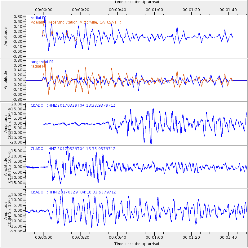
Signal To Noise
| Channel | StoN | STA | LTA |
| CI:ADO: :HHZ:20170329T04:18:33.937971Z | 13.590905 | 5.168905E-6 | 3.8032084E-7 |
| CI:ADO: :HHN:20170329T04:18:33.937971Z | 4.587768 | 3.0823737E-6 | 6.718678E-7 |
| CI:ADO: :HHE:20170329T04:18:33.937971Z | 1.6391313 | 1.0039821E-6 | 6.1250864E-7 |
| Arrivals |
| Ps | 4.7 SECOND |
| PpPs | 13 SECOND |
| PsPs/PpSs | 18 SECOND |


