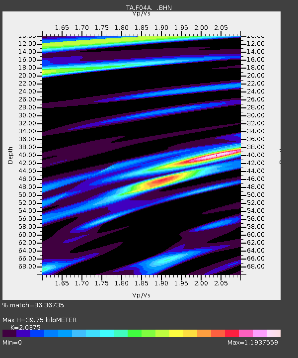
F04A Amboy, WA, USA - Earthquake Result Viewer
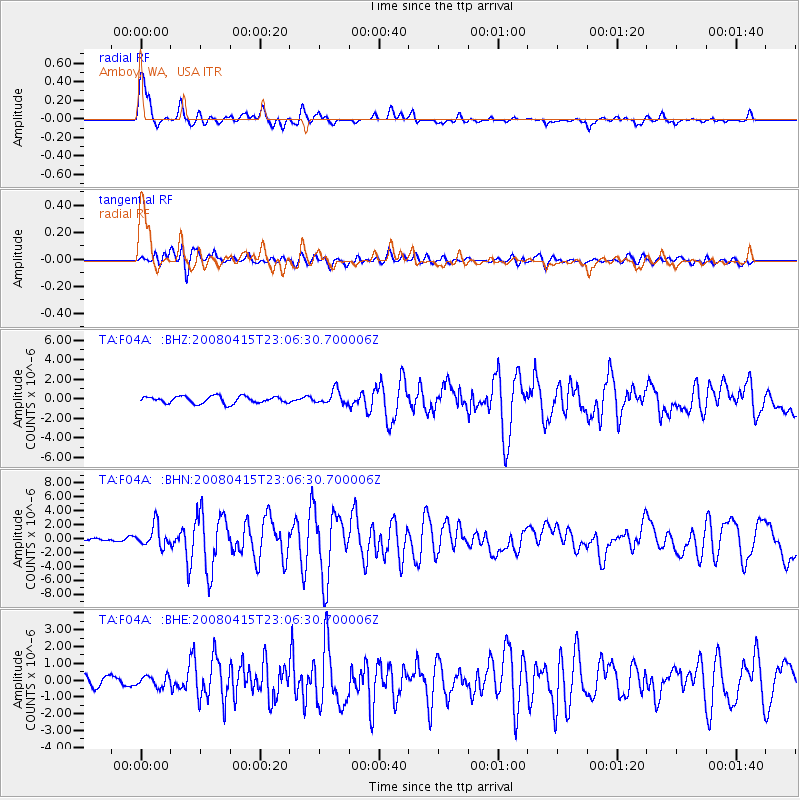
Earthquake location: Andreanof Islands, Aleutian Is.
Earthquake latitude/longitude: 51.9/-179.4
Earthquake time(UTC): 2008/04/15 (106) 22:59:51 GMT
Earthquake Depth: 10 km
Earthquake Magnitude: 6.1 MB, 6.4 MS, 6.4 MW, 6.4 MW
Earthquake Catalog/Contributor: WHDF/NEIC
Network: TA USArray Transportable Network (new EarthScope stations)
Station: F04A Amboy, WA, USA
Lat/Lon: 45.93 N/122.42 W
Elevation: 211 m
Distance: 37.1 deg
Az: 76.027 deg
Baz: 300.413 deg
Ray Param: 0.076338
Estimated Moho Depth: 39.75 km
Estimated Crust Vp/Vs: 2.04
Assumed Crust Vp: 6.566 km/s
Estimated Crust Vs: 3.223 km/s
Estimated Crust Poisson's Ratio: 0.34
Radial Match: 86.36735 %
Radial Bump: 375
Transverse Match: 60.619576 %
Transverse Bump: 400
SOD ConfigId: 2504
Insert Time: 2010-03-05 22:39:01.349 +0000
GWidth: 2.5
Max Bumps: 400
Tol: 0.001

Signal To Noise

ChannelStoNSTALTA
TA:F04A: :BHN:20080415T23:06:30.700006Z5.48648551.5365715E-62.800648E-7
TA:F04A: :BHE:20080415T23:06:30.700006Z1.16146673.2669809E-72.8128062E-7
TA:F04A: :BHZ:20080415T23:06:30.700006Z1.96319746.96983E-73.5502444E-7
Arrivals
Ps6.7 SECOND
PpPs17 SECOND
PsPs/PpSs24 SECOND