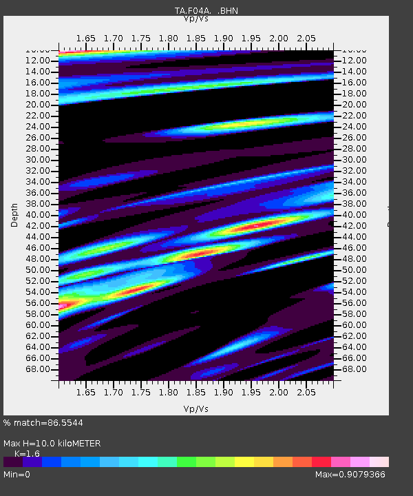
F04A Amboy, WA, USA - Earthquake Result Viewer
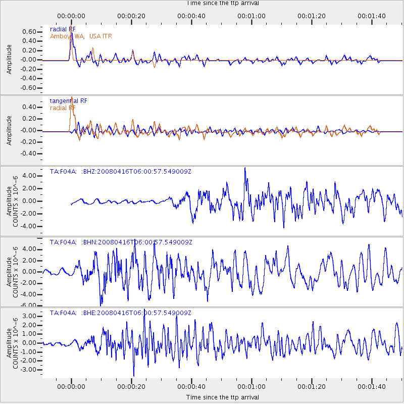
Earthquake location: Andreanof Islands, Aleutian Is.
Earthquake latitude/longitude: 51.9/-179.2
Earthquake time(UTC): 2008/04/16 (107) 05:54:19 GMT
Earthquake Depth: 13 km
Earthquake Magnitude: 6.1 MB, 6.5 MS, 6.6 MW, 6.6 MW
Earthquake Catalog/Contributor: WHDF/NEIC
Network: TA USArray Transportable Network (new EarthScope stations)
Station: F04A Amboy, WA, USA
Lat/Lon: 45.93 N/122.42 W
Elevation: 211 m
Distance: 36.9 deg
Az: 76.171 deg
Baz: 300.404 deg
Ray Param: 0.076397136
Estimated Moho Depth: 10.0 km
Estimated Crust Vp/Vs: 1.60
Assumed Crust Vp: 6.566 km/s
Estimated Crust Vs: 4.104 km/s
Estimated Crust Poisson's Ratio: 0.18
Radial Match: 86.5544 %
Radial Bump: 400
Transverse Match: 65.904976 %
Transverse Bump: 400
SOD ConfigId: 2504
Insert Time: 2010-03-05 22:39:03.267 +0000
GWidth: 2.5
Max Bumps: 400
Tol: 0.001

Signal To Noise

ChannelStoNSTALTA
TA:F04A: :BHN:20080416T06:00:57.549009Z4.24912369.748162E-72.2941585E-7
TA:F04A: :BHE:20080416T06:00:57.549009Z1.38340963.4833366E-72.5179358E-7
TA:F04A: :BHZ:20080416T06:00:57.549009Z1.92005774.1855768E-72.1799225E-7
Arrivals
Ps1.0 SECOND
PpPs3.6 SECOND
PsPs/PpSs4.6 SECOND