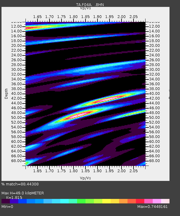
F04A Amboy, WA, USA - Earthquake Result Viewer
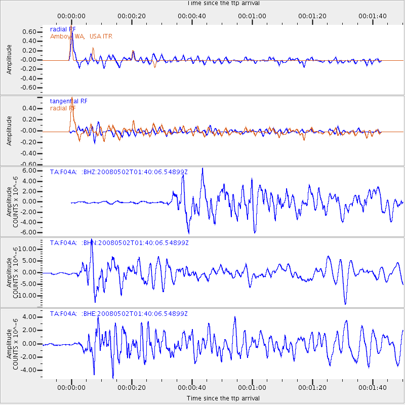
Earthquake location: Andreanof Islands, Aleutian Is.
Earthquake latitude/longitude: 51.9/-177.5
Earthquake time(UTC): 2008/05/02 (123) 01:33:37 GMT
Earthquake Depth: 14 km
Earthquake Magnitude: 6.3 MB, 6.8 MS, 6.6 MW, 6.6 MW
Earthquake Catalog/Contributor: WHDF/NEIC
Network: TA USArray Transportable Network (new EarthScope stations)
Station: F04A Amboy, WA, USA
Lat/Lon: 45.93 N/122.42 W
Elevation: 211 m
Distance: 36.0 deg
Az: 77.12 deg
Baz: 299.987 deg
Ray Param: 0.07693078
Estimated Moho Depth: 49.0 km
Estimated Crust Vp/Vs: 1.82
Assumed Crust Vp: 6.566 km/s
Estimated Crust Vs: 3.618 km/s
Estimated Crust Poisson's Ratio: 0.28
Radial Match: 88.44308 %
Radial Bump: 400
Transverse Match: 78.281815 %
Transverse Bump: 400
SOD ConfigId: 2504
Insert Time: 2010-03-05 22:39:06.603 +0000
GWidth: 2.5
Max Bumps: 400
Tol: 0.001

Signal To Noise

ChannelStoNSTALTA
TA:F04A: :BHN:20080502T01:40:06.54899Z8.9078291.4512299E-61.6291622E-7
TA:F04A: :BHE:20080502T01:40:06.54899Z3.22167184.290199E-71.3316686E-7
TA:F04A: :BHZ:20080502T01:40:06.54899Z5.3633067.4721436E-71.3931972E-7
Arrivals
Ps6.6 SECOND
PpPs19 SECOND
PsPs/PpSs26 SECOND