You are here: Home > Network List > CI - Caltech Regional Seismic Network Stations List
> Station MPP McPhearson Peak > Earthquake Result Viewer
MPP McPhearson Peak - Earthquake Result Viewer
| Earthquake location: |
Near East Coast Of Kamchatka |
| Earthquake latitude/longitude: |
56.9/162.7 |
| Earthquake time(UTC): |
2017/03/29 (088) 04:09:24 GMT |
| Earthquake Depth: |
23 km |
| Earthquake Magnitude: |
6.6 Mww |
| Earthquake Catalog/Contributor: |
NEIC PDE/us |
|
| Network: |
CI Caltech Regional Seismic Network |
| Station: |
MPP McPhearson Peak |
| Lat/Lon: |
34.89 N/119.81 W |
| Elevation: |
1739 m |
|
| Distance: |
55.0 deg |
| Az: |
78.525 deg |
| Baz: |
319.176 deg |
| Ray Param: |
0.06507515 |
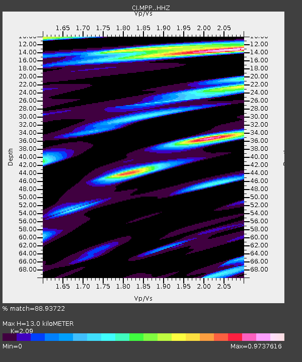
| Estimated Moho Depth: |
13.0 km |
| Estimated Crust Vp/Vs: |
2.09 |
| Assumed Crust Vp: |
6.1 km/s |
| Estimated Crust Vs: |
2.919 km/s |
| Estimated Crust Poisson's Ratio: |
0.35 |
|
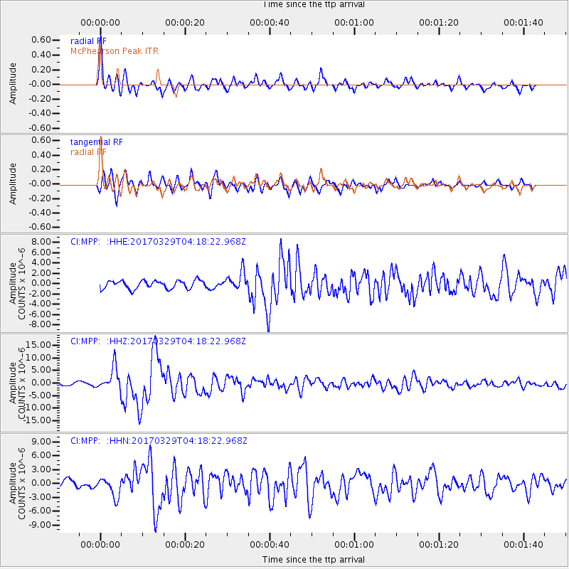
| Radial Match: |
88.93722 % |
| Radial Bump: |
400 |
| Transverse Match: |
87.16248 % |
| Transverse Bump: |
400 |
| SOD ConfigId: |
11737051 |
| Insert Time: |
2019-04-27 00:18:51.536 +0000 |
| GWidth: |
2.5 |
| Max Bumps: |
400 |
| Tol: |
0.001 |
|
Signal To Noise
| Channel | StoN | STA | LTA |
| CI:MPP: :HHZ:20170329T04:18:22.968Z | 9.747924 | 4.693498E-6 | 4.8148695E-7 |
| CI:MPP: :HHN:20170329T04:18:22.968Z | 3.5104911 | 2.0905547E-6 | 5.955164E-7 |
| CI:MPP: :HHE:20170329T04:18:22.968Z | 2.2638988 | 1.7768949E-6 | 7.848827E-7 |
| Arrivals |
| Ps | 2.4 SECOND |
| PpPs | 6.3 SECOND |
| PsPs/PpSs | 8.7 SECOND |


