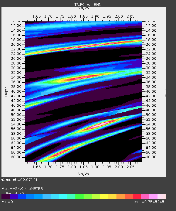
F04A Amboy, WA, USA - Earthquake Result Viewer
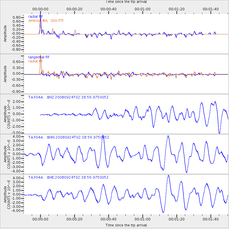
Earthquake location: Off Coast Of Jalisco, Mexico
Earthquake latitude/longitude: 17.6/-105.5
Earthquake time(UTC): 2008/09/24 (268) 02:33:05 GMT
Earthquake Depth: 10 km
Earthquake Magnitude: 5.7 MB, 6.2 MS, 6.4 MW, 6.4 MW
Earthquake Catalog/Contributor: WHDF/NEIC
Network: TA USArray Transportable Network (new EarthScope stations)
Station: F04A Amboy, WA, USA
Lat/Lon: 45.93 N/122.42 W
Elevation: 211 m
Distance: 31.6 deg
Az: 337.163 deg
Baz: 147.969 deg
Ray Param: 0.079026885
Estimated Moho Depth: 54.0 km
Estimated Crust Vp/Vs: 1.92
Assumed Crust Vp: 6.566 km/s
Estimated Crust Vs: 3.424 km/s
Estimated Crust Poisson's Ratio: 0.31
Radial Match: 92.97121 %
Radial Bump: 292
Transverse Match: 72.29542 %
Transverse Bump: 400
SOD ConfigId: 2560
Insert Time: 2010-03-05 22:39:29.462 +0000
GWidth: 2.5
Max Bumps: 400
Tol: 0.001

Signal To Noise

ChannelStoNSTALTA
TA:F04A: :BHN:20080924T02:38:56.975005Z10.1815991.4084968E-61.383375E-7
TA:F04A: :BHE:20080924T02:38:56.975005Z5.8395588.075953E-71.3829732E-7
TA:F04A: :BHZ:20080924T02:38:56.975005Z6.87619645.393966E-77.844403E-8
Arrivals
Ps8.2 SECOND
PpPs22 SECOND
PsPs/PpSs30 SECOND