You are here: Home > Network List > CN - Canadian National Seismograph Network Stations List
> Station KUKN Kugluktuk, NT, CA > Earthquake Result Viewer
KUKN Kugluktuk, NT, CA - Earthquake Result Viewer
| Earthquake location: |
Near East Coast Of Kamchatka |
| Earthquake latitude/longitude: |
56.9/162.7 |
| Earthquake time(UTC): |
2017/03/29 (088) 04:09:24 GMT |
| Earthquake Depth: |
23 km |
| Earthquake Magnitude: |
6.6 Mww |
| Earthquake Catalog/Contributor: |
NEIC PDE/us |
|
| Network: |
CN Canadian National Seismograph Network |
| Station: |
KUKN Kugluktuk, NT, CA |
| Lat/Lon: |
67.82 N/115.09 W |
| Elevation: |
51 m |
|
| Distance: |
36.7 deg |
| Az: |
39.022 deg |
| Baz: |
294.573 deg |
| Ray Param: |
0.07651525 |
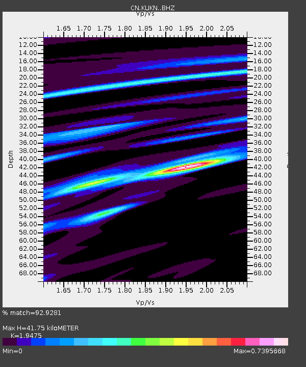
| Estimated Moho Depth: |
41.75 km |
| Estimated Crust Vp/Vs: |
1.95 |
| Assumed Crust Vp: |
6.459 km/s |
| Estimated Crust Vs: |
3.317 km/s |
| Estimated Crust Poisson's Ratio: |
0.32 |
|
| Radial Match: |
92.9281 % |
| Radial Bump: |
400 |
| Transverse Match: |
56.101006 % |
| Transverse Bump: |
400 |
| SOD ConfigId: |
11737051 |
| Insert Time: |
2019-04-27 00:19:55.022 +0000 |
| GWidth: |
2.5 |
| Max Bumps: |
400 |
| Tol: |
0.001 |
|

Signal To Noise
| Channel | StoN | STA | LTA |
| CN:KUKN: :BHZ:20170329T04:15:58.925001Z | 14.72976 | 5.1785464E-6 | 3.515703E-7 |
| CN:KUKN: :BHN:20170329T04:15:58.925001Z | 5.8695173 | 1.4800237E-6 | 2.5215422E-7 |
| CN:KUKN: :BHE:20170329T04:15:58.925001Z | 14.804035 | 3.244002E-6 | 2.191296E-7 |
| Arrivals |
| Ps | 6.6 SECOND |
| PpPs | 18 SECOND |
| PsPs/PpSs | 24 SECOND |


