You are here: Home > Network List > CI - Caltech Regional Seismic Network Stations List
> Station DAN Danby, California, USA > Earthquake Result Viewer
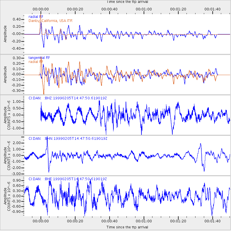
DAN Danby, California, USA - Earthquake Result Viewer
*The percent match for this event was below the threshold and hence no stack was calculated.
| Earthquake location: |
Northwest Of Kuril Islands |
| Earthquake latitude/longitude: |
47.5/147.2 |
| Earthquake time(UTC): |
1999/02/05 (036) 14:37:53 GMT |
| Earthquake Depth: |
407 km |
| Earthquake Magnitude: |
6.0 MW, 5.4 MB, 5.8 MW |
| Earthquake Catalog/Contributor: |
WHDF/NEIC |
|
| Network: |
CI Caltech Regional Seismic Network |
| Station: |
DAN Danby, California, USA |
| Lat/Lon: |
34.64 N/115.38 W |
| Elevation: |
398 m |
|
| Distance: |
69.9 deg |
| Az: |
60.513 deg |
| Baz: |
314.295 deg |
| Ray Param: |
$rayparam |
*The percent match for this event was below the threshold and hence was not used in the summary stack. |
|
| Radial Match: |
79.53341 % |
| Radial Bump: |
400 |
| Transverse Match: |
66.6504 % |
| Transverse Bump: |
400 |
| SOD ConfigId: |
4480 |
| Insert Time: |
2010-02-26 01:05:32.333 +0000 |
| GWidth: |
2.5 |
| Max Bumps: |
400 |
| Tol: |
0.001 |
|
Signal To Noise
| Channel | StoN | STA | LTA |
| CI:DAN: :BHN:19990205T14:47:50.619019Z | 2.478037 | 1.111742E-6 | 4.4863816E-7 |
| CI:DAN: :BHE:19990205T14:47:50.619019Z | 0.9643905 | 4.0590703E-7 | 4.2089488E-7 |
| CI:DAN: :BHZ:19990205T14:47:50.619019Z | 1.0808086 | 3.9567593E-7 | 3.6609248E-7 |
| Arrivals |
| Ps | |
| PpPs | |
| PsPs/PpSs | |


