You are here: Home > Network List > CN - Canadian National Seismograph Network Stations List
> Station MALO Mcalpine Lake, ON, CA > Earthquake Result Viewer
MALO Mcalpine Lake, ON, CA - Earthquake Result Viewer
| Earthquake location: |
Near East Coast Of Kamchatka |
| Earthquake latitude/longitude: |
56.9/162.7 |
| Earthquake time(UTC): |
2017/03/29 (088) 04:09:24 GMT |
| Earthquake Depth: |
23 km |
| Earthquake Magnitude: |
6.6 Mww |
| Earthquake Catalog/Contributor: |
NEIC PDE/us |
|
| Network: |
CN Canadian National Seismograph Network |
| Station: |
MALO Mcalpine Lake, ON, CA |
| Lat/Lon: |
50.02 N/79.76 W |
| Elevation: |
271 m |
|
| Distance: |
61.6 deg |
| Az: |
40.572 deg |
| Baz: |
326.428 deg |
| Ray Param: |
0.06074521 |
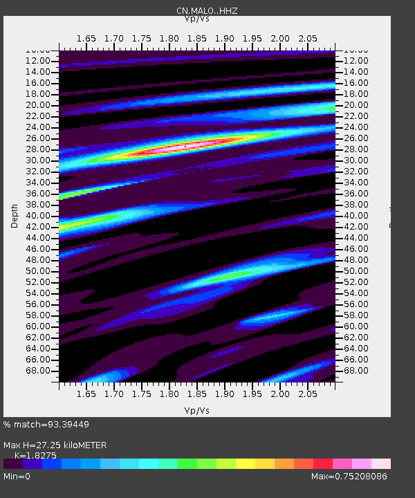
| Estimated Moho Depth: |
27.25 km |
| Estimated Crust Vp/Vs: |
1.83 |
| Assumed Crust Vp: |
6.459 km/s |
| Estimated Crust Vs: |
3.535 km/s |
| Estimated Crust Poisson's Ratio: |
0.29 |
|
| Radial Match: |
93.39449 % |
| Radial Bump: |
231 |
| Transverse Match: |
86.81376 % |
| Transverse Bump: |
290 |
| SOD ConfigId: |
11737051 |
| Insert Time: |
2019-04-27 00:19:56.683 +0000 |
| GWidth: |
2.5 |
| Max Bumps: |
400 |
| Tol: |
0.001 |
|

Signal To Noise
| Channel | StoN | STA | LTA |
| CN:MALO: :HHZ:20170329T04:19:09.239973Z | 13.947778 | 4.289407E-6 | 3.0753338E-7 |
| CN:MALO: :HHN:20170329T04:19:09.239973Z | 5.3257213 | 1.0480497E-6 | 1.967902E-7 |
| CN:MALO: :HHE:20170329T04:19:09.239973Z | 8.563688 | 1.8872382E-6 | 2.2037679E-7 |
| Arrivals |
| Ps | 3.6 SECOND |
| PpPs | 11 SECOND |
| PsPs/PpSs | 15 SECOND |


