You are here: Home > Network List > CN - Canadian National Seismograph Network Stations List
> Station LMQ LA MALBAIE, QC > Earthquake Result Viewer
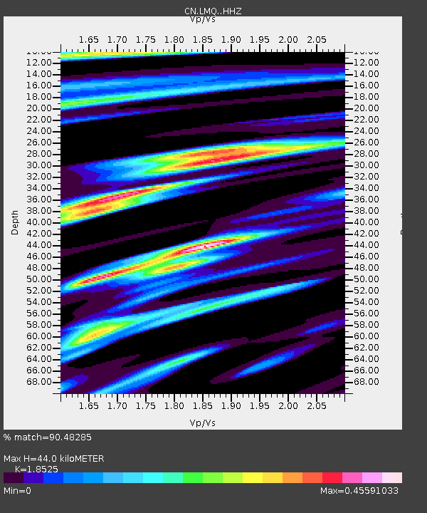
LMQ LA MALBAIE, QC - Earthquake Result Viewer
| Earthquake location: |
Near East Coast Of Kamchatka |
| Earthquake latitude/longitude: |
56.9/162.7 |
| Earthquake time(UTC): |
2017/03/29 (088) 04:09:24 GMT |
| Earthquake Depth: |
23 km |
| Earthquake Magnitude: |
6.6 Mww |
| Earthquake Catalog/Contributor: |
NEIC PDE/us |
|
| Network: |
CN Canadian National Seismograph Network |
| Station: |
LMQ LA MALBAIE, QC |
| Lat/Lon: |
47.55 N/70.33 W |
| Elevation: |
429 m |
|
| Distance: |
66.9 deg |
| Az: |
36.052 deg |
| Baz: |
331.55 deg |
| Ray Param: |
0.057261415 |
| Estimated Moho Depth: |
44.0 km |
| Estimated Crust Vp/Vs: |
1.85 |
| Assumed Crust Vp: |
6.61 km/s |
| Estimated Crust Vs: |
3.568 km/s |
| Estimated Crust Poisson's Ratio: |
0.29 |
|
| Radial Match: |
90.48285 % |
| Radial Bump: |
265 |
| Transverse Match: |
80.10104 % |
| Transverse Bump: |
400 |
| SOD ConfigId: |
11737051 |
| Insert Time: |
2019-04-27 00:19:56.904 +0000 |
| GWidth: |
2.5 |
| Max Bumps: |
400 |
| Tol: |
0.001 |
|

Signal To Noise
| Channel | StoN | STA | LTA |
| CN:LMQ: :HHZ:20170329T04:19:44.150007Z | 19.498703 | 4.6502582E-6 | 2.3849063E-7 |
| CN:LMQ: :HHN:20170329T04:19:44.150007Z | 7.5802774 | 1.9067091E-6 | 2.5153554E-7 |
| CN:LMQ: :HHE:20170329T04:19:44.150007Z | 7.366998 | 1.213095E-6 | 1.646661E-7 |
| Arrivals |
| Ps | 5.9 SECOND |
| PpPs | 18 SECOND |
| PsPs/PpSs | 24 SECOND |


