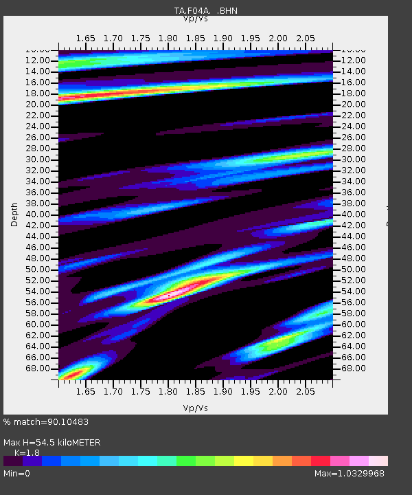
F04A Amboy, WA, USA - Earthquake Result Viewer
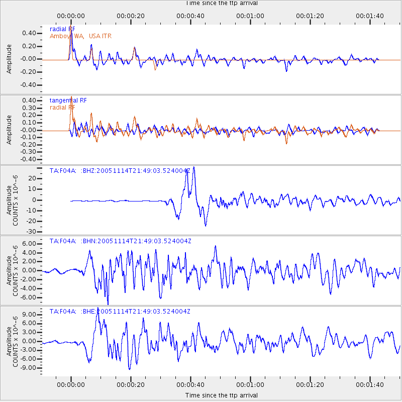
Earthquake location: Off East Coast Of Honshu, Japan
Earthquake latitude/longitude: 38.1/144.9
Earthquake time(UTC): 2005/11/14 (318) 21:38:51 GMT
Earthquake Depth: 11 km
Earthquake Magnitude: 6.7 MB, 6.8 MS, 7.0 MW, 6.9 MW
Earthquake Catalog/Contributor: WHDF/NEIC
Network: TA USArray Transportable Network (new EarthScope stations)
Station: F04A Amboy, WA, USA
Lat/Lon: 45.93 N/122.42 W
Elevation: 211 m
Distance: 65.5 deg
Az: 49.996 deg
Baz: 300.023 deg
Ray Param: 0.058214907
Estimated Moho Depth: 54.5 km
Estimated Crust Vp/Vs: 1.80
Assumed Crust Vp: 6.566 km/s
Estimated Crust Vs: 3.648 km/s
Estimated Crust Poisson's Ratio: 0.28
Radial Match: 90.10483 %
Radial Bump: 400
Transverse Match: 82.1339 %
Transverse Bump: 400
SOD ConfigId: 2448
Insert Time: 2010-03-05 22:39:48.272 +0000
GWidth: 2.5
Max Bumps: 400
Tol: 0.001

Signal To Noise

ChannelStoNSTALTA
TA:F04A: :BHN:20051114T21:49:03.524004Z1.25003623.7536861E-73.0028616E-7
TA:F04A: :BHE:20051114T21:49:03.524004Z2.2065015.5473544E-72.5140955E-7
TA:F04A: :BHZ:20051114T21:49:03.524004Z9.1170412.5833608E-62.8335518E-7
Arrivals
Ps6.9 SECOND
PpPs22 SECOND
PsPs/PpSs29 SECOND