You are here: Home > Network List > TA - USArray Transportable Network (new EarthScope stations) Stations List
> Station F04A Amboy, WA, USA > Earthquake Result Viewer
F04A Amboy, WA, USA - Earthquake Result Viewer
| Earthquake location: |
Vanuatu Islands |
| Earthquake latitude/longitude: |
-15.6/167.7 |
| Earthquake time(UTC): |
2007/08/01 (213) 17:08:51 GMT |
| Earthquake Depth: |
120 km |
| Earthquake Magnitude: |
6.2 MB, 7.2 MW, 7.2 MW |
| Earthquake Catalog/Contributor: |
WHDF/NEIC |
|
| Network: |
TA USArray Transportable Network (new EarthScope stations) |
| Station: |
F04A Amboy, WA, USA |
| Lat/Lon: |
45.93 N/122.42 W |
| Elevation: |
211 m |
|
| Distance: |
87.7 deg |
| Az: |
40.99 deg |
| Baz: |
244.915 deg |
| Ray Param: |
0.04285934 |
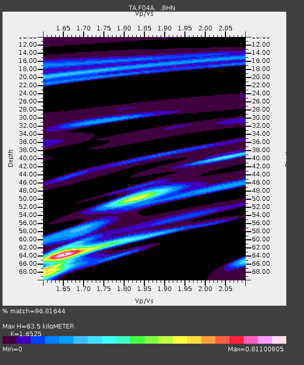
| Estimated Moho Depth: |
63.5 km |
| Estimated Crust Vp/Vs: |
1.65 |
| Assumed Crust Vp: |
6.566 km/s |
| Estimated Crust Vs: |
3.973 km/s |
| Estimated Crust Poisson's Ratio: |
0.21 |
|
| Radial Match: |
96.81644 % |
| Radial Bump: |
291 |
| Transverse Match: |
89.19559 % |
| Transverse Bump: |
400 |
| SOD ConfigId: |
2564 |
| Insert Time: |
2010-03-05 22:39:57.014 +0000 |
| GWidth: |
2.5 |
| Max Bumps: |
400 |
| Tol: |
0.001 |
|
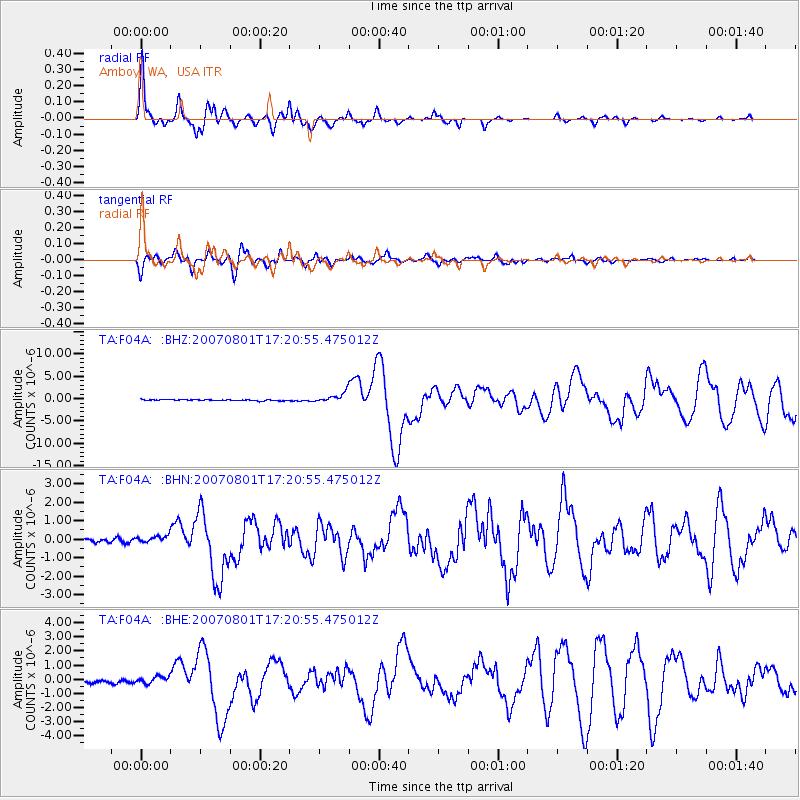
Signal To Noise
| Channel | StoN | STA | LTA |
| TA:F04A: :BHN:20070801T17:20:55.475012Z | 2.5177538 | 2.0041217E-7 | 7.959959E-8 |
| TA:F04A: :BHE:20070801T17:20:55.475012Z | 3.9504004 | 2.685857E-7 | 6.798948E-8 |
| TA:F04A: :BHZ:20070801T17:20:55.475012Z | 9.549137 | 1.1594785E-6 | 1.2142235E-7 |
| Arrivals |
| Ps | 6.5 SECOND |
| PpPs | 25 SECOND |
| PsPs/PpSs | 31 SECOND |


