You are here: Home > Network List > TA - USArray Transportable Network (new EarthScope stations) Stations List
> Station F04A Amboy, WA, USA > Earthquake Result Viewer
F04A Amboy, WA, USA - Earthquake Result Viewer
| Earthquake location: |
Peru-Ecuador Border Region |
| Earthquake latitude/longitude: |
-2.3/-77.8 |
| Earthquake time(UTC): |
2007/11/16 (320) 03:13:00 GMT |
| Earthquake Depth: |
123 km |
| Earthquake Magnitude: |
6.3 MB, 6.8 MW, 6.7 MW |
| Earthquake Catalog/Contributor: |
WHDF/NEIC |
|
| Network: |
TA USArray Transportable Network (new EarthScope stations) |
| Station: |
F04A Amboy, WA, USA |
| Lat/Lon: |
45.93 N/122.42 W |
| Elevation: |
211 m |
|
| Distance: |
62.1 deg |
| Az: |
326.335 deg |
| Baz: |
127.474 deg |
| Ray Param: |
0.060095925 |
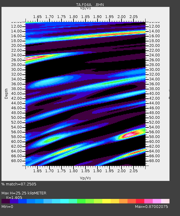
| Estimated Moho Depth: |
25.25 km |
| Estimated Crust Vp/Vs: |
1.61 |
| Assumed Crust Vp: |
6.566 km/s |
| Estimated Crust Vs: |
4.091 km/s |
| Estimated Crust Poisson's Ratio: |
0.18 |
|
| Radial Match: |
87.2585 % |
| Radial Bump: |
400 |
| Transverse Match: |
70.86767 % |
| Transverse Bump: |
400 |
| SOD ConfigId: |
2564 |
| Insert Time: |
2010-03-05 22:40:15.545 +0000 |
| GWidth: |
2.5 |
| Max Bumps: |
400 |
| Tol: |
0.001 |
|

Signal To Noise
| Channel | StoN | STA | LTA |
| TA:F04A: :BHN:20071116T03:22:37.174016Z | 0.9325293 | 4.7295197E-7 | 5.0717114E-7 |
| TA:F04A: :BHE:20071116T03:22:37.174016Z | 0.98234224 | 4.223879E-7 | 4.2998036E-7 |
| TA:F04A: :BHZ:20071116T03:22:37.174016Z | 2.753538 | 1.1734685E-6 | 4.2616753E-7 |
| Arrivals |
| Ps | 2.4 SECOND |
| PpPs | 9.5 SECOND |
| PsPs/PpSs | 12 SECOND |


