You are here: Home > Network List > TA - USArray Transportable Network (new EarthScope stations) Stations List
> Station POKR Poker Plat Research Range, AK, USA > Earthquake Result Viewer
POKR Poker Plat Research Range, AK, USA - Earthquake Result Viewer
| Earthquake location: |
Solomon Islands |
| Earthquake latitude/longitude: |
-8.9/158.4 |
| Earthquake time(UTC): |
2015/11/18 (322) 18:31:04 GMT |
| Earthquake Depth: |
11 km |
| Earthquake Magnitude: |
6.8 MWB, 7.0 MI |
| Earthquake Catalog/Contributor: |
NEIC PDE/NEIC COMCAT |
|
| Network: |
TA USArray Transportable Network (new EarthScope stations) |
| Station: |
POKR Poker Plat Research Range, AK, USA |
| Lat/Lon: |
65.12 N/147.43 W |
| Elevation: |
501 m |
|
| Distance: |
84.0 deg |
| Az: |
20.171 deg |
| Baz: |
233.632 deg |
| Ray Param: |
0.045799885 |
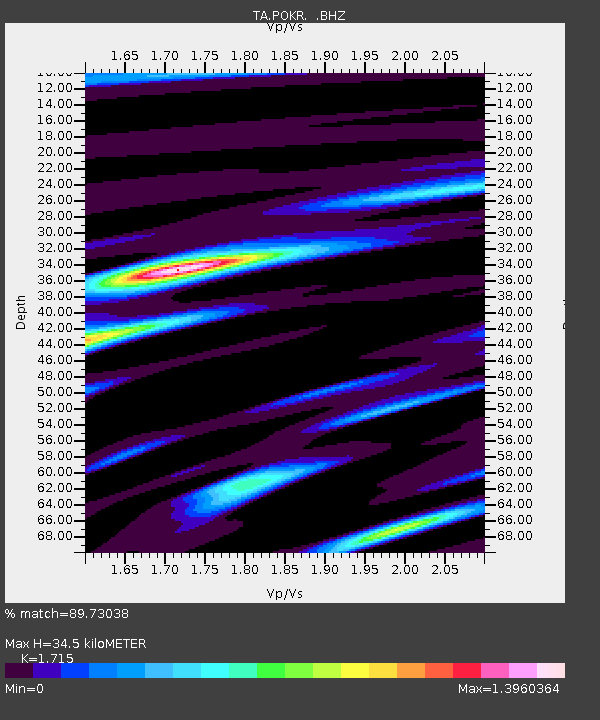
| Estimated Moho Depth: |
34.5 km |
| Estimated Crust Vp/Vs: |
1.72 |
| Assumed Crust Vp: |
6.566 km/s |
| Estimated Crust Vs: |
3.829 km/s |
| Estimated Crust Poisson's Ratio: |
0.24 |
|
| Radial Match: |
89.73038 % |
| Radial Bump: |
400 |
| Transverse Match: |
71.15152 % |
| Transverse Bump: |
400 |
| SOD ConfigId: |
1259291 |
| Insert Time: |
2015-12-02 19:20:10.574 +0000 |
| GWidth: |
2.5 |
| Max Bumps: |
400 |
| Tol: |
0.001 |
|
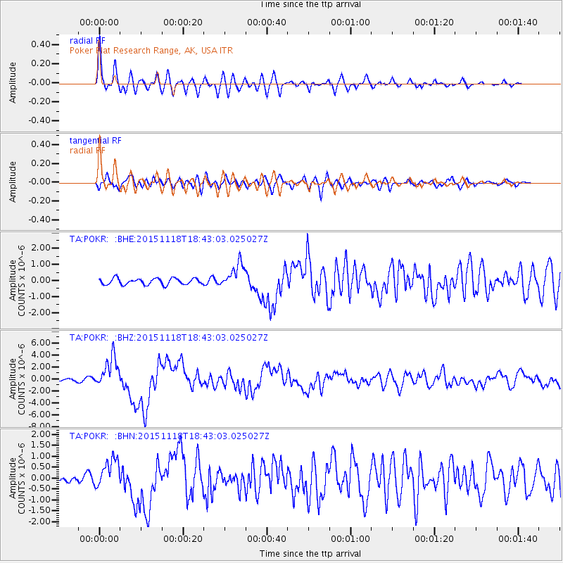
Signal To Noise
| Channel | StoN | STA | LTA |
| TA:POKR: :BHZ:20151118T18:43:03.025027Z | 11.869897 | 2.6356306E-6 | 2.2204325E-7 |
| TA:POKR: :BHN:20151118T18:43:03.025027Z | 2.8920524 | 6.7783884E-7 | 2.3437987E-7 |
| TA:POKR: :BHE:20151118T18:43:03.025027Z | 4.044246 | 7.819368E-7 | 1.933455E-7 |
| Arrivals |
| Ps | 3.9 SECOND |
| PpPs | 14 SECOND |
| PsPs/PpSs | 18 SECOND |


