You are here: Home > Network List > TA - USArray Transportable Network (new EarthScope stations) Stations List
> Station F04A Amboy, WA, USA > Earthquake Result Viewer
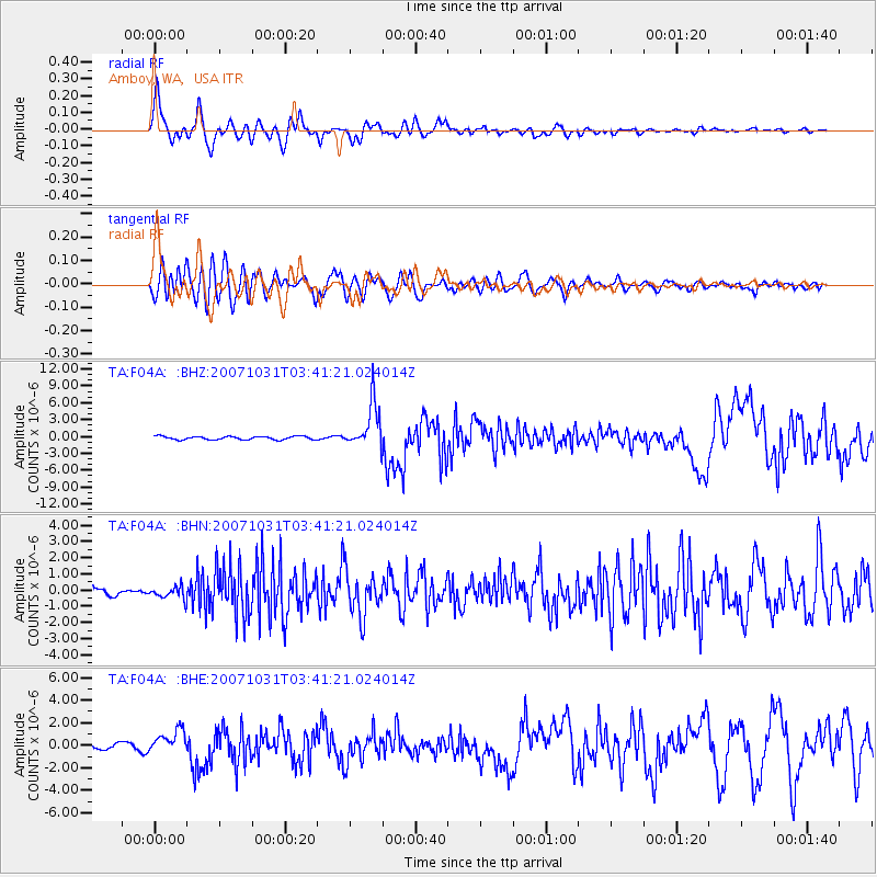
F04A Amboy, WA, USA - Earthquake Result Viewer

| Earthquake location: |
Mariana Islands |
| Earthquake latitude/longitude: |
18.9/145.4 |
| Earthquake time(UTC): |
2007/10/31 (304) 03:30:17 GMT |
| Earthquake Depth: |
223 km |
| Earthquake Magnitude: |
6.2 MB, 7.2 MW, 7.2 MW |
| Earthquake Catalog/Contributor: |
WHDF/NEIC |
|
| Network: |
TA USArray Transportable Network (new EarthScope stations) |
| Station: |
F04A Amboy, WA, USA |
| Lat/Lon: |
45.93 N/122.42 W |
| Elevation: |
211 m |
|
| Distance: |
78.2 deg |
| Az: |
45.44 deg |
| Baz: |
284.853 deg |
| Ray Param: |
0.049248304 |
| Estimated Moho Depth: |
40.25 km |
| Estimated Crust Vp/Vs: |
2.10 |
| Assumed Crust Vp: |
6.566 km/s |
| Estimated Crust Vs: |
3.13 km/s |
| Estimated Crust Poisson's Ratio: |
0.35 |
|
| Radial Match: |
91.636665 % |
| Radial Bump: |
400 |
| Transverse Match: |
78.37328 % |
| Transverse Bump: |
400 |
| SOD ConfigId: |
2564 |
| Insert Time: |
2010-03-05 22:40:19.616 +0000 |
| GWidth: |
2.5 |
| Max Bumps: |
400 |
| Tol: |
0.001 |
|
Signal To Noise
| Channel | StoN | STA | LTA |
| TA:F04A: :BHN:20071031T03:41:21.024014Z | 1.1925051 | 3.712237E-7 | 3.1129736E-7 |
| TA:F04A: :BHE:20071031T03:41:21.024014Z | 4.6887245 | 1.0352412E-6 | 2.2079378E-7 |
| TA:F04A: :BHZ:20071031T03:41:21.024014Z | 13.36871 | 3.9838965E-6 | 2.9800157E-7 |
| Arrivals |
| Ps | 6.9 SECOND |
| PpPs | 19 SECOND |
| PsPs/PpSs | 25 SECOND |


