You are here: Home > Network List > TA - USArray Transportable Network (new EarthScope stations) Stations List
> Station F04A Amboy, WA, USA > Earthquake Result Viewer
F04A Amboy, WA, USA - Earthquake Result Viewer
| Earthquake location: |
Taiwan Region |
| Earthquake latitude/longitude: |
24.3/122.2 |
| Earthquake time(UTC): |
2007/09/06 (249) 17:51:26 GMT |
| Earthquake Depth: |
53 km |
| Earthquake Magnitude: |
6.1 MB, 6.2 MW, 6.1 ME |
| Earthquake Catalog/Contributor: |
WHDF/NEIC |
|
| Network: |
TA USArray Transportable Network (new EarthScope stations) |
| Station: |
F04A Amboy, WA, USA |
| Lat/Lon: |
45.93 N/122.42 W |
| Elevation: |
211 m |
|
| Distance: |
88.8 deg |
| Az: |
39.108 deg |
| Baz: |
304.47 deg |
| Ray Param: |
0.04222337 |
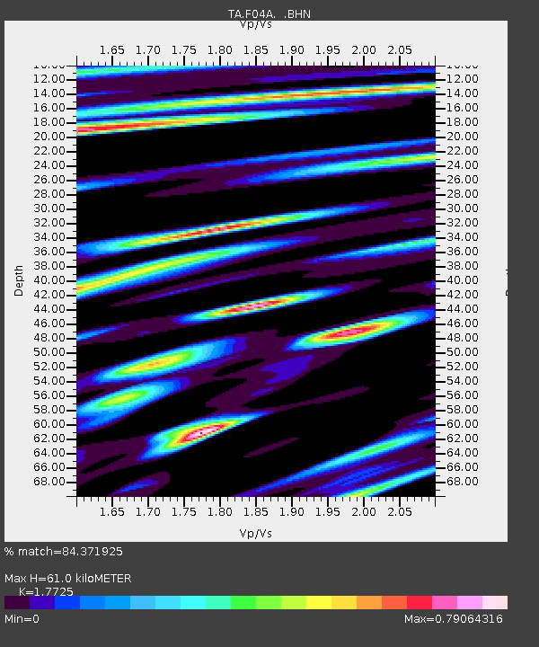
| Estimated Moho Depth: |
61.0 km |
| Estimated Crust Vp/Vs: |
1.77 |
| Assumed Crust Vp: |
6.566 km/s |
| Estimated Crust Vs: |
3.704 km/s |
| Estimated Crust Poisson's Ratio: |
0.27 |
|
| Radial Match: |
84.371925 % |
| Radial Bump: |
400 |
| Transverse Match: |
73.382965 % |
| Transverse Bump: |
400 |
| SOD ConfigId: |
2564 |
| Insert Time: |
2010-03-05 22:40:24.918 +0000 |
| GWidth: |
2.5 |
| Max Bumps: |
400 |
| Tol: |
0.001 |
|
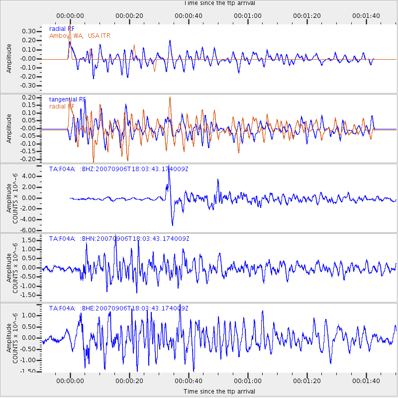
Signal To Noise
| Channel | StoN | STA | LTA |
| TA:F04A: :BHN:20070906T18:03:43.174009Z | 1.5725405 | 2.1246821E-7 | 1.3511143E-7 |
| TA:F04A: :BHE:20070906T18:03:43.174009Z | 4.4031157 | 5.036642E-7 | 1.14388136E-7 |
| TA:F04A: :BHZ:20070906T18:03:43.174009Z | 14.932189 | 2.2364898E-6 | 1.4977641E-7 |
| Arrivals |
| Ps | 7.3 SECOND |
| PpPs | 25 SECOND |
| PsPs/PpSs | 33 SECOND |


