You are here: Home > Network List > TA - USArray Transportable Network (new EarthScope stations) Stations List
> Station F04A Amboy, WA, USA > Earthquake Result Viewer
F04A Amboy, WA, USA - Earthquake Result Viewer
| Earthquake location: |
Solomon Islands |
| Earthquake latitude/longitude: |
-9.8/159.5 |
| Earthquake time(UTC): |
2007/08/16 (228) 08:39:27 GMT |
| Earthquake Depth: |
10 km |
| Earthquake Magnitude: |
6.1 MB, 6.7 MS, 6.4 MW |
| Earthquake Catalog/Contributor: |
WHDF/NEIC |
|
| Network: |
TA USArray Transportable Network (new EarthScope stations) |
| Station: |
F04A Amboy, WA, USA |
| Lat/Lon: |
45.93 N/122.42 W |
| Elevation: |
211 m |
|
| Distance: |
88.8 deg |
| Az: |
43.085 deg |
| Baz: |
254.704 deg |
| Ray Param: |
0.04228429 |
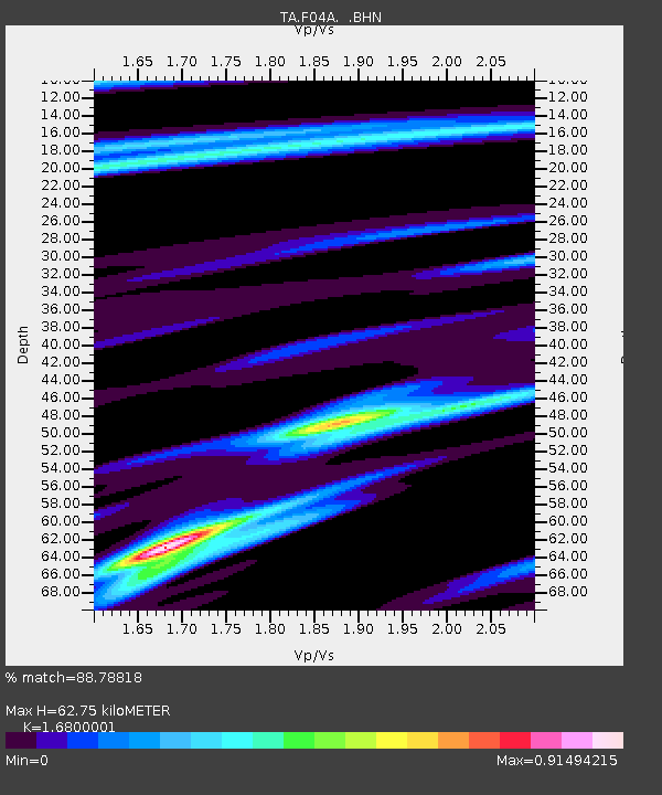
| Estimated Moho Depth: |
62.75 km |
| Estimated Crust Vp/Vs: |
1.68 |
| Assumed Crust Vp: |
6.566 km/s |
| Estimated Crust Vs: |
3.908 km/s |
| Estimated Crust Poisson's Ratio: |
0.23 |
|
| Radial Match: |
88.78818 % |
| Radial Bump: |
317 |
| Transverse Match: |
87.77253 % |
| Transverse Bump: |
400 |
| SOD ConfigId: |
2564 |
| Insert Time: |
2010-03-05 22:40:31.946 +0000 |
| GWidth: |
2.5 |
| Max Bumps: |
400 |
| Tol: |
0.001 |
|

Signal To Noise
| Channel | StoN | STA | LTA |
| TA:F04A: :BHN:20070816T08:51:50.224014Z | 3.1010337 | 1.2617805E-7 | 4.068903E-8 |
| TA:F04A: :BHE:20070816T08:51:50.224014Z | 2.6009755 | 1.3536807E-7 | 5.2045113E-8 |
| TA:F04A: :BHZ:20070816T08:51:50.224014Z | 9.44379 | 4.4960885E-7 | 4.7608943E-8 |
| Arrivals |
| Ps | 6.7 SECOND |
| PpPs | 25 SECOND |
| PsPs/PpSs | 32 SECOND |


