You are here: Home > Network List > JP - Japan Meteorological Agency Seismic Network Stations List
> Station JTU Tsushima Kamiagata > Earthquake Result Viewer
JTU Tsushima Kamiagata - Earthquake Result Viewer
| Earthquake location: |
Near East Coast Of Kamchatka |
| Earthquake latitude/longitude: |
56.9/162.7 |
| Earthquake time(UTC): |
2017/03/29 (088) 04:09:24 GMT |
| Earthquake Depth: |
23 km |
| Earthquake Magnitude: |
6.6 Mww |
| Earthquake Catalog/Contributor: |
NEIC PDE/us |
|
| Network: |
JP Japan Meteorological Agency Seismic Network |
| Station: |
JTU Tsushima Kamiagata |
| Lat/Lon: |
34.53 N/129.40 E |
| Elevation: |
70 m |
|
| Distance: |
31.8 deg |
| Az: |
239.488 deg |
| Baz: |
34.905 deg |
| Ray Param: |
0.078904875 |
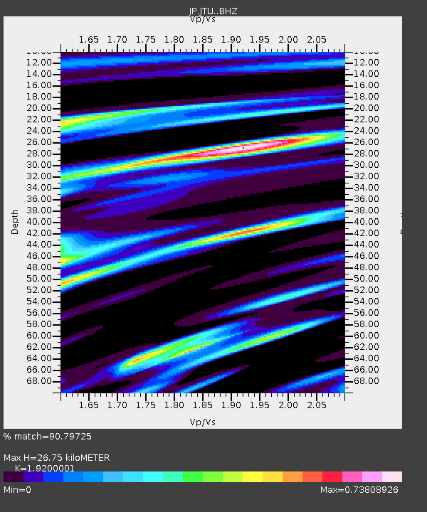
| Estimated Moho Depth: |
26.75 km |
| Estimated Crust Vp/Vs: |
1.92 |
| Assumed Crust Vp: |
6.472 km/s |
| Estimated Crust Vs: |
3.371 km/s |
| Estimated Crust Poisson's Ratio: |
0.31 |
|
| Radial Match: |
90.79725 % |
| Radial Bump: |
339 |
| Transverse Match: |
70.47532 % |
| Transverse Bump: |
400 |
| SOD ConfigId: |
11737051 |
| Insert Time: |
2019-04-27 00:22:27.090 +0000 |
| GWidth: |
2.5 |
| Max Bumps: |
400 |
| Tol: |
0.001 |
|

Signal To Noise
| Channel | StoN | STA | LTA |
| JP:JTU: :BHZ:20170329T04:15:17.150007Z | 6.354405 | 1.4020619E-6 | 2.206441E-7 |
| JP:JTU: :BHN:20170329T04:15:17.150007Z | 3.4859765 | 6.555135E-7 | 1.88043E-7 |
| JP:JTU: :BHE:20170329T04:15:17.150007Z | 3.92642 | 7.504508E-7 | 1.911285E-7 |
| Arrivals |
| Ps | 4.1 SECOND |
| PpPs | 11 SECOND |
| PsPs/PpSs | 15 SECOND |


