You are here: Home > Network List > KZ - Kazakhstan Network Stations List
> Station ABKAR Akbulak array,AB31, Kazakhstan > Earthquake Result Viewer
ABKAR Akbulak array,AB31, Kazakhstan - Earthquake Result Viewer
| Earthquake location: |
Near East Coast Of Kamchatka |
| Earthquake latitude/longitude: |
56.9/162.7 |
| Earthquake time(UTC): |
2017/03/29 (088) 04:09:24 GMT |
| Earthquake Depth: |
23 km |
| Earthquake Magnitude: |
6.6 Mww |
| Earthquake Catalog/Contributor: |
NEIC PDE/us |
|
| Network: |
KZ Kazakhstan Network |
| Station: |
ABKAR Akbulak array,AB31, Kazakhstan |
| Lat/Lon: |
49.26 N/59.94 E |
| Elevation: |
362 m |
|
| Distance: |
56.5 deg |
| Az: |
309.971 deg |
| Baz: |
39.898 deg |
| Ray Param: |
0.0640818 |
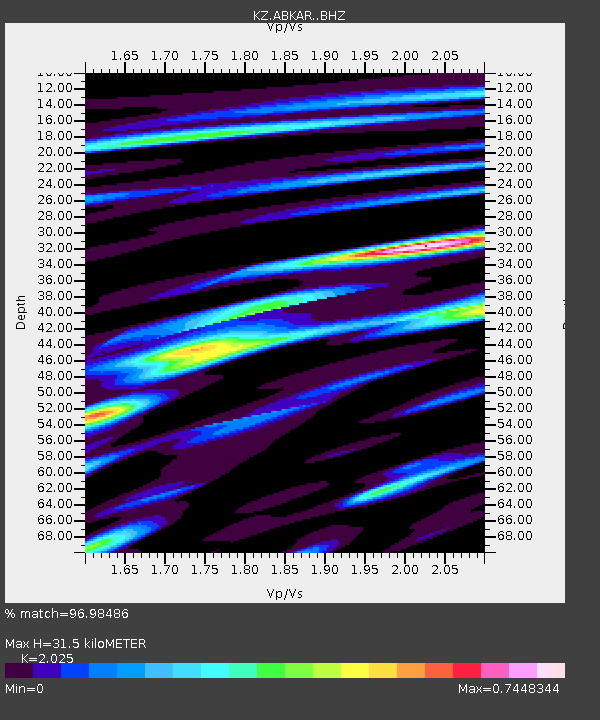
| Estimated Moho Depth: |
31.5 km |
| Estimated Crust Vp/Vs: |
2.03 |
| Assumed Crust Vp: |
6.35 km/s |
| Estimated Crust Vs: |
3.136 km/s |
| Estimated Crust Poisson's Ratio: |
0.34 |
|
| Radial Match: |
96.98486 % |
| Radial Bump: |
296 |
| Transverse Match: |
90.469795 % |
| Transverse Bump: |
400 |
| SOD ConfigId: |
11737051 |
| Insert Time: |
2019-04-27 00:22:50.152 +0000 |
| GWidth: |
2.5 |
| Max Bumps: |
400 |
| Tol: |
0.001 |
|

Signal To Noise
| Channel | StoN | STA | LTA |
| KZ:ABKAR: :BHZ:20170329T04:18:34.150984Z | 46.325214 | 4.1512135E-6 | 8.961023E-8 |
| KZ:ABKAR: :BHN:20170329T04:18:34.150984Z | 13.546381 | 1.4221823E-6 | 1.0498614E-7 |
| KZ:ABKAR: :BHE:20170329T04:18:34.150984Z | 20.972364 | 2.1295677E-6 | 1.01541616E-7 |
| Arrivals |
| Ps | 5.3 SECOND |
| PpPs | 14 SECOND |
| PsPs/PpSs | 20 SECOND |


