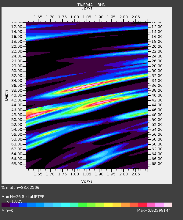
F04A Amboy, WA, USA - Earthquake Result Viewer
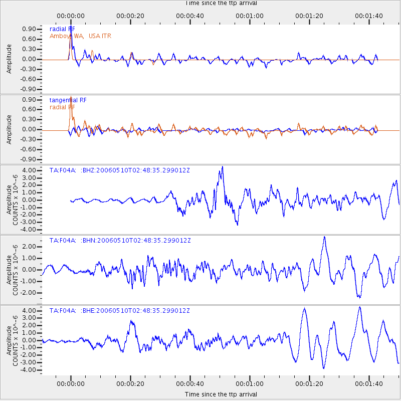
Earthquake location: Fox Islands, Aleutian Islands
Earthquake latitude/longitude: 52.5/-169.3
Earthquake time(UTC): 2006/05/10 (130) 02:42:51 GMT
Earthquake Depth: 18 km
Earthquake Magnitude: 6.1 MB, 6.2 MS, 6.4 MW, 6.3 MW
Earthquake Catalog/Contributor: WHDF/NEIC
Network: TA USArray Transportable Network (new EarthScope stations)
Station: F04A Amboy, WA, USA
Lat/Lon: 45.93 N/122.42 W
Elevation: 211 m
Distance: 30.8 deg
Az: 83.303 deg
Baz: 299.579 deg
Ray Param: 0.07921806
Estimated Moho Depth: 36.5 km
Estimated Crust Vp/Vs: 1.83
Assumed Crust Vp: 6.566 km/s
Estimated Crust Vs: 3.598 km/s
Estimated Crust Poisson's Ratio: 0.29
Radial Match: 83.02566 %
Radial Bump: 400
Transverse Match: 66.0209 %
Transverse Bump: 400
SOD ConfigId: 2669
Insert Time: 2010-03-05 22:41:09.936 +0000
GWidth: 2.5
Max Bumps: 400
Tol: 0.001

Signal To Noise

ChannelStoNSTALTA
TA:F04A: :BHN:20060510T02:48:35.299012Z0.543116151.425397E-72.6244788E-7
TA:F04A: :BHE:20060510T02:48:35.299012Z0.58195741.9564189E-73.3617906E-7
TA:F04A: :BHZ:20060510T02:48:35.299012Z3.1312445.641325E-71.8016242E-7
Arrivals
Ps5.0 SECOND
PpPs14 SECOND
PsPs/PpSs19 SECOND