You are here: Home > Network List > N4 - Central and EAstern US Network Stations List
> Station 451A Vernon, FL, USA > Earthquake Result Viewer
451A Vernon, FL, USA - Earthquake Result Viewer
| Earthquake location: |
Near East Coast Of Kamchatka |
| Earthquake latitude/longitude: |
56.9/162.7 |
| Earthquake time(UTC): |
2017/03/29 (088) 04:09:24 GMT |
| Earthquake Depth: |
23 km |
| Earthquake Magnitude: |
6.6 Mww |
| Earthquake Catalog/Contributor: |
NEIC PDE/us |
|
| Network: |
N4 Central and EAstern US Network |
| Station: |
451A Vernon, FL, USA |
| Lat/Lon: |
30.62 N/85.75 W |
| Elevation: |
20 m |
|
| Distance: |
75.5 deg |
| Az: |
55.933 deg |
| Baz: |
328.202 deg |
| Ray Param: |
0.05160064 |
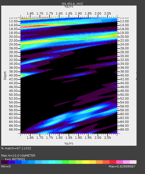
| Estimated Moho Depth: |
10.0 km |
| Estimated Crust Vp/Vs: |
1.61 |
| Assumed Crust Vp: |
6.347 km/s |
| Estimated Crust Vs: |
3.948 km/s |
| Estimated Crust Poisson's Ratio: |
0.18 |
|
| Radial Match: |
87.11032 % |
| Radial Bump: |
399 |
| Transverse Match: |
68.229645 % |
| Transverse Bump: |
400 |
| SOD ConfigId: |
11737051 |
| Insert Time: |
2019-04-27 00:23:53.608 +0000 |
| GWidth: |
2.5 |
| Max Bumps: |
400 |
| Tol: |
0.001 |
|

Signal To Noise
| Channel | StoN | STA | LTA |
| N4:451A: :HHZ:20170329T04:20:35.889998Z | 29.55009 | 1.07949345E-5 | 3.6530972E-7 |
| N4:451A: :HHN:20170329T04:20:35.889998Z | 4.5391994 | 1.9310442E-6 | 4.2541518E-7 |
| N4:451A: :HHE:20170329T04:20:35.889998Z | 3.6216564 | 1.2924191E-6 | 3.5685858E-7 |
| Arrivals |
| Ps | 1.0 SECOND |
| PpPs | 4.0 SECOND |
| PsPs/PpSs | 5.0 SECOND |


