You are here: Home > Network List > N4 - Central and EAstern US Network Stations List
> Station J47A Sunmer, MI, USA > Earthquake Result Viewer
J47A Sunmer, MI, USA - Earthquake Result Viewer
| Earthquake location: |
Near East Coast Of Kamchatka |
| Earthquake latitude/longitude: |
56.9/162.7 |
| Earthquake time(UTC): |
2017/03/29 (088) 04:09:24 GMT |
| Earthquake Depth: |
23 km |
| Earthquake Magnitude: |
6.6 Mww |
| Earthquake Catalog/Contributor: |
NEIC PDE/us |
|
| Network: |
N4 Central and EAstern US Network |
| Station: |
J47A Sunmer, MI, USA |
| Lat/Lon: |
43.24 N/84.82 W |
| Elevation: |
236 m |
|
| Distance: |
65.3 deg |
| Az: |
48.025 deg |
| Baz: |
326.092 deg |
| Ray Param: |
0.05833134 |
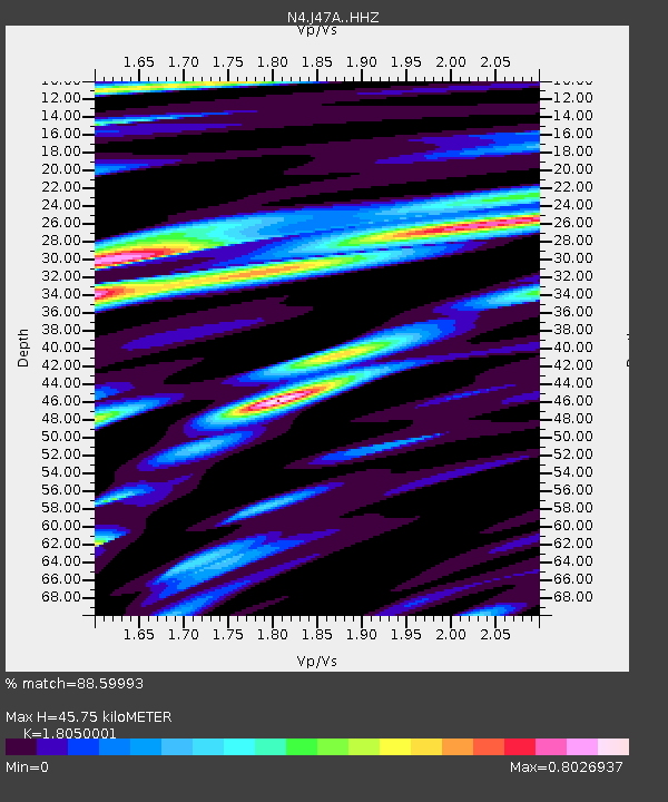
| Estimated Moho Depth: |
45.75 km |
| Estimated Crust Vp/Vs: |
1.81 |
| Assumed Crust Vp: |
6.483 km/s |
| Estimated Crust Vs: |
3.591 km/s |
| Estimated Crust Poisson's Ratio: |
0.28 |
|
| Radial Match: |
88.59993 % |
| Radial Bump: |
400 |
| Transverse Match: |
72.75071 % |
| Transverse Bump: |
400 |
| SOD ConfigId: |
11737051 |
| Insert Time: |
2019-04-27 00:24:21.847 +0000 |
| GWidth: |
2.5 |
| Max Bumps: |
400 |
| Tol: |
0.001 |
|

Signal To Noise
| Channel | StoN | STA | LTA |
| N4:J47A: :HHZ:20170329T04:19:33.720015Z | 17.342133 | 5.698107E-6 | 3.2857014E-7 |
| N4:J47A: :HHN:20170329T04:19:33.720015Z | 9.221408 | 2.13398E-6 | 2.3141585E-7 |
| N4:J47A: :HHE:20170329T04:19:33.720015Z | 5.7019944 | 1.5650479E-6 | 2.744738E-7 |
| Arrivals |
| Ps | 5.9 SECOND |
| PpPs | 19 SECOND |
| PsPs/PpSs | 25 SECOND |


