You are here: Home > Network List > N4 - Central and EAstern US Network Stations List
> Station P53A Whipple, OH, USA > Earthquake Result Viewer
P53A Whipple, OH, USA - Earthquake Result Viewer
| Earthquake location: |
Near East Coast Of Kamchatka |
| Earthquake latitude/longitude: |
56.9/162.7 |
| Earthquake time(UTC): |
2017/03/29 (088) 04:09:24 GMT |
| Earthquake Depth: |
23 km |
| Earthquake Magnitude: |
6.6 Mww |
| Earthquake Catalog/Contributor: |
NEIC PDE/us |
|
| Network: |
N4 Central and EAstern US Network |
| Station: |
P53A Whipple, OH, USA |
| Lat/Lon: |
39.49 N/81.39 W |
| Elevation: |
270 m |
|
| Distance: |
69.9 deg |
| Az: |
47.872 deg |
| Baz: |
328.295 deg |
| Ray Param: |
0.05534378 |
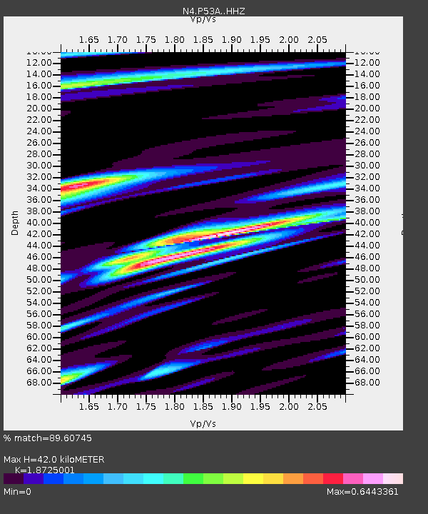
| Estimated Moho Depth: |
42.0 km |
| Estimated Crust Vp/Vs: |
1.87 |
| Assumed Crust Vp: |
6.207 km/s |
| Estimated Crust Vs: |
3.315 km/s |
| Estimated Crust Poisson's Ratio: |
0.30 |
|
| Radial Match: |
89.60745 % |
| Radial Bump: |
393 |
| Transverse Match: |
82.03538 % |
| Transverse Bump: |
400 |
| SOD ConfigId: |
11737051 |
| Insert Time: |
2019-04-27 00:25:00.993 +0000 |
| GWidth: |
2.5 |
| Max Bumps: |
400 |
| Tol: |
0.001 |
|

Signal To Noise
| Channel | StoN | STA | LTA |
| N4:P53A: :HHZ:20170329T04:20:02.389998Z | 17.303835 | 3.5559171E-6 | 2.054988E-7 |
| N4:P53A: :HHN:20170329T04:20:02.389998Z | 10.795882 | 1.8169527E-6 | 1.6830053E-7 |
| N4:P53A: :HHE:20170329T04:20:02.389998Z | 4.789835 | 1.0619963E-6 | 2.2171878E-7 |
| Arrivals |
| Ps | 6.1 SECOND |
| PpPs | 19 SECOND |
| PsPs/PpSs | 25 SECOND |


