You are here: Home > Network List > N4 - Central and EAstern US Network Stations List
> Station R49A Shelbyville, KY, USA > Earthquake Result Viewer
R49A Shelbyville, KY, USA - Earthquake Result Viewer
| Earthquake location: |
Near East Coast Of Kamchatka |
| Earthquake latitude/longitude: |
56.9/162.7 |
| Earthquake time(UTC): |
2017/03/29 (088) 04:09:24 GMT |
| Earthquake Depth: |
23 km |
| Earthquake Magnitude: |
6.6 Mww |
| Earthquake Catalog/Contributor: |
NEIC PDE/us |
|
| Network: |
N4 Central and EAstern US Network |
| Station: |
R49A Shelbyville, KY, USA |
| Lat/Lon: |
38.29 N/85.17 W |
| Elevation: |
251 m |
|
| Distance: |
69.3 deg |
| Az: |
51.214 deg |
| Baz: |
327.096 deg |
| Ray Param: |
0.055722304 |
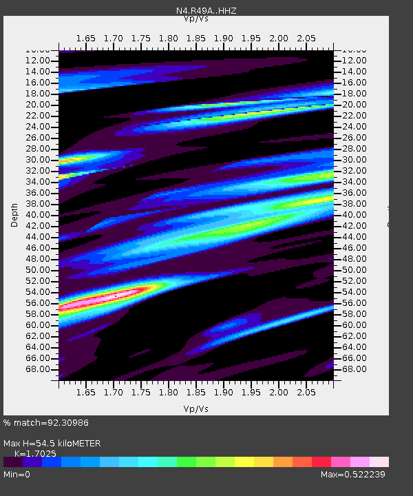
| Estimated Moho Depth: |
54.5 km |
| Estimated Crust Vp/Vs: |
1.70 |
| Assumed Crust Vp: |
6.498 km/s |
| Estimated Crust Vs: |
3.816 km/s |
| Estimated Crust Poisson's Ratio: |
0.24 |
|
| Radial Match: |
92.30986 % |
| Radial Bump: |
304 |
| Transverse Match: |
79.89215 % |
| Transverse Bump: |
400 |
| SOD ConfigId: |
11737051 |
| Insert Time: |
2019-04-27 00:25:07.613 +0000 |
| GWidth: |
2.5 |
| Max Bumps: |
400 |
| Tol: |
0.001 |
|

Signal To Noise
| Channel | StoN | STA | LTA |
| N4:R49A: :HHZ:20170329T04:19:58.889998Z | 17.946093 | 4.766931E-6 | 2.65625E-7 |
| N4:R49A: :HHN:20170329T04:19:58.889998Z | 14.090103 | 1.7483526E-6 | 1.2408373E-7 |
| N4:R49A: :HHE:20170329T04:19:58.889998Z | 10.32639 | 1.144597E-6 | 1.1084193E-7 |
| Arrivals |
| Ps | 6.1 SECOND |
| PpPs | 22 SECOND |
| PsPs/PpSs | 28 SECOND |


