You are here: Home > Network List > N4 - Central and EAstern US Network Stations List
> Station Y49A Blount Mountain, AL, USA > Earthquake Result Viewer
Y49A Blount Mountain, AL, USA - Earthquake Result Viewer
| Earthquake location: |
Near East Coast Of Kamchatka |
| Earthquake latitude/longitude: |
56.9/162.7 |
| Earthquake time(UTC): |
2017/03/29 (088) 04:09:24 GMT |
| Earthquake Depth: |
23 km |
| Earthquake Magnitude: |
6.6 Mww |
| Earthquake Catalog/Contributor: |
NEIC PDE/us |
|
| Network: |
N4 Central and EAstern US Network |
| Station: |
Y49A Blount Mountain, AL, USA |
| Lat/Lon: |
33.86 N/86.41 W |
| Elevation: |
362 m |
|
| Distance: |
72.5 deg |
| Az: |
54.64 deg |
| Baz: |
327.492 deg |
| Ray Param: |
0.05361652 |
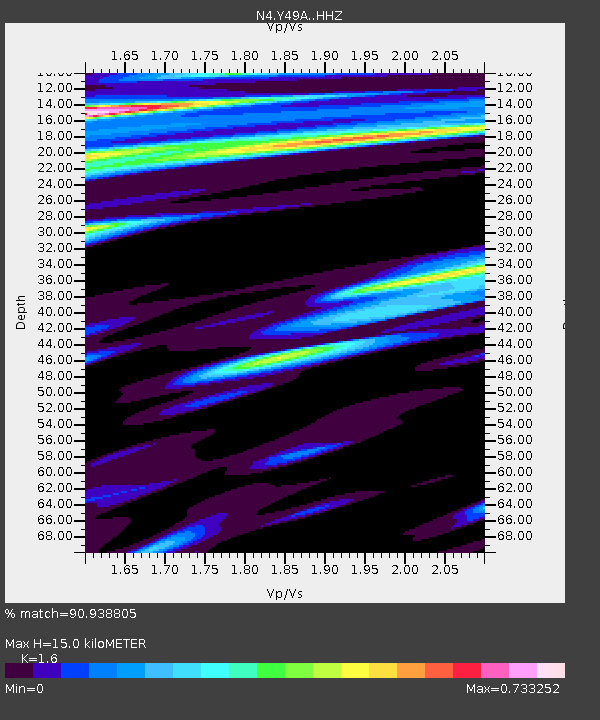
| Estimated Moho Depth: |
15.0 km |
| Estimated Crust Vp/Vs: |
1.60 |
| Assumed Crust Vp: |
6.565 km/s |
| Estimated Crust Vs: |
4.103 km/s |
| Estimated Crust Poisson's Ratio: |
0.18 |
|
| Radial Match: |
90.938805 % |
| Radial Bump: |
400 |
| Transverse Match: |
80.410446 % |
| Transverse Bump: |
400 |
| SOD ConfigId: |
11737051 |
| Insert Time: |
2019-04-27 00:25:39.402 +0000 |
| GWidth: |
2.5 |
| Max Bumps: |
400 |
| Tol: |
0.001 |
|

Signal To Noise
| Channel | StoN | STA | LTA |
| N4:Y49A: :HHZ:20170329T04:20:18.170027Z | 26.422415 | 6.394869E-6 | 2.4202438E-7 |
| N4:Y49A: :HHN:20170329T04:20:18.170027Z | 12.053074 | 1.207208E-6 | 1.00157685E-7 |
| N4:Y49A: :HHE:20170329T04:20:18.170027Z | 5.4709797 | 8.8062785E-7 | 1.6096347E-7 |
| Arrivals |
| Ps | 1.4 SECOND |
| PpPs | 5.7 SECOND |
| PsPs/PpSs | 7.1 SECOND |


