You are here: Home > Network List > N4 - Central and EAstern US Network Stations List
> Station Z51A Franklin, GA, USA > Earthquake Result Viewer
Z51A Franklin, GA, USA - Earthquake Result Viewer
| Earthquake location: |
Near East Coast Of Kamchatka |
| Earthquake latitude/longitude: |
56.9/162.7 |
| Earthquake time(UTC): |
2017/03/29 (088) 04:09:24 GMT |
| Earthquake Depth: |
23 km |
| Earthquake Magnitude: |
6.6 Mww |
| Earthquake Catalog/Contributor: |
NEIC PDE/us |
|
| Network: |
N4 Central and EAstern US Network |
| Station: |
Z51A Franklin, GA, USA |
| Lat/Lon: |
33.32 N/85.17 W |
| Elevation: |
249 m |
|
| Distance: |
73.5 deg |
| Az: |
54.027 deg |
| Baz: |
327.993 deg |
| Ray Param: |
0.052955206 |
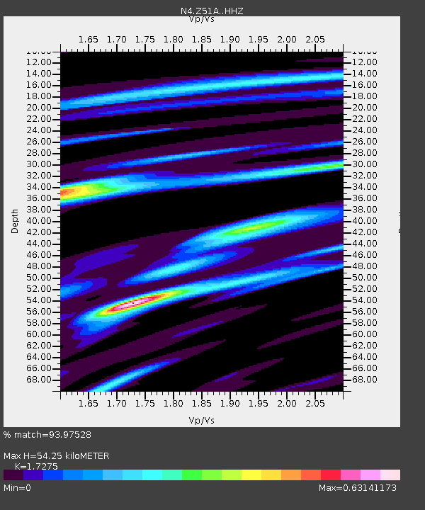
| Estimated Moho Depth: |
54.25 km |
| Estimated Crust Vp/Vs: |
1.73 |
| Assumed Crust Vp: |
6.719 km/s |
| Estimated Crust Vs: |
3.89 km/s |
| Estimated Crust Poisson's Ratio: |
0.25 |
|
| Radial Match: |
93.97528 % |
| Radial Bump: |
310 |
| Transverse Match: |
80.386734 % |
| Transverse Bump: |
400 |
| SOD ConfigId: |
11737051 |
| Insert Time: |
2019-04-27 00:25:43.848 +0000 |
| GWidth: |
2.5 |
| Max Bumps: |
400 |
| Tol: |
0.001 |
|

Signal To Noise
| Channel | StoN | STA | LTA |
| N4:Z51A: :HHZ:20170329T04:20:24.129988Z | 30.893345 | 4.297761E-6 | 1.3911608E-7 |
| N4:Z51A: :HHN:20170329T04:20:24.129988Z | 11.035472 | 1.5223776E-6 | 1.3795311E-7 |
| N4:Z51A: :HHE:20170329T04:20:24.129988Z | 10.693133 | 1.0707447E-6 | 1.0013386E-7 |
| Arrivals |
| Ps | 6.1 SECOND |
| PpPs | 21 SECOND |
| PsPs/PpSs | 27 SECOND |


