You are here: Home > Network List > TA - USArray Transportable Network (new EarthScope stations) Stations List
> Station F04A Amboy, WA, USA > Earthquake Result Viewer
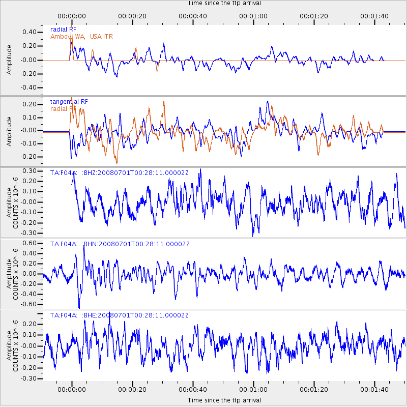
F04A Amboy, WA, USA - Earthquake Result Viewer
*The percent match for this event was below the threshold and hence no stack was calculated.
| Earthquake location: |
Central Peru |
| Earthquake latitude/longitude: |
-10.4/-75.5 |
| Earthquake time(UTC): |
2008/07/01 (183) 00:17:33 GMT |
| Earthquake Depth: |
33 km |
| Earthquake Magnitude: |
5.5 MW, 5.0 MS, 5.4 MB, 5.3 ML |
| Earthquake Catalog/Contributor: |
WHDF/NEIC |
|
| Network: |
TA USArray Transportable Network (new EarthScope stations) |
| Station: |
F04A Amboy, WA, USA |
| Lat/Lon: |
45.93 N/122.42 W |
| Elevation: |
211 m |
|
| Distance: |
70.1 deg |
| Az: |
327.169 deg |
| Baz: |
130.155 deg |
| Ray Param: |
$rayparam |
*The percent match for this event was below the threshold and hence was not used in the summary stack. |
|
| Radial Match: |
48.410763 % |
| Radial Bump: |
400 |
| Transverse Match: |
35.26804 % |
| Transverse Bump: |
400 |
| SOD ConfigId: |
2504 |
| Insert Time: |
2010-03-05 22:41:48.220 +0000 |
| GWidth: |
2.5 |
| Max Bumps: |
400 |
| Tol: |
0.001 |
|
Signal To Noise
| Channel | StoN | STA | LTA |
| TA:F04A: :BHN:20080701T00:28:11.00002Z | 4.308987 | 2.925586E-7 | 6.789498E-8 |
| TA:F04A: :BHE:20080701T00:28:11.00002Z | 0.88180935 | 9.742837E-8 | 1.10486894E-7 |
| TA:F04A: :BHZ:20080701T00:28:11.00002Z | 1.2104863 | 1.2145058E-7 | 1.0033206E-7 |
| Arrivals |
| Ps | |
| PpPs | |
| PsPs/PpSs | |


