You are here: Home > Network List > NN - Western Great Basin/Eastern Sierra Nevada Stations List
> Station LCH Last Chance Range, CA. (GPS 01/04/2001) w84 > Earthquake Result Viewer
LCH Last Chance Range, CA. (GPS 01/04/2001) w84 - Earthquake Result Viewer
| Earthquake location: |
Near East Coast Of Kamchatka |
| Earthquake latitude/longitude: |
56.9/162.7 |
| Earthquake time(UTC): |
2017/03/29 (088) 04:09:24 GMT |
| Earthquake Depth: |
23 km |
| Earthquake Magnitude: |
6.6 Mww |
| Earthquake Catalog/Contributor: |
NEIC PDE/us |
|
| Network: |
NN Western Great Basin/Eastern Sierra Nevada |
| Station: |
LCH Last Chance Range, CA. (GPS 01/04/2001) w84 |
| Lat/Lon: |
37.23 N/117.65 W |
| Elevation: |
1414 m |
|
| Distance: |
54.4 deg |
| Az: |
75.015 deg |
| Baz: |
318.417 deg |
| Ray Param: |
0.06546507 |
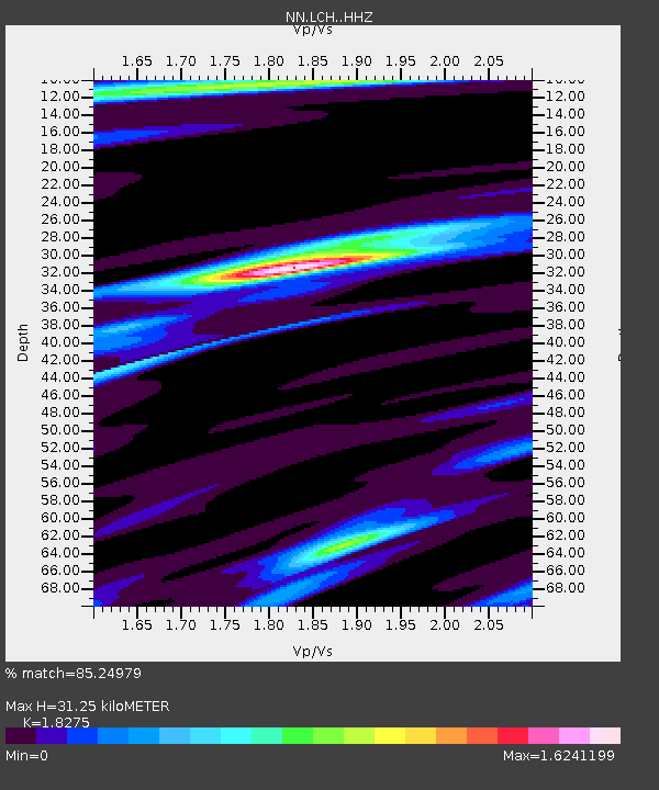
| Estimated Moho Depth: |
31.25 km |
| Estimated Crust Vp/Vs: |
1.83 |
| Assumed Crust Vp: |
6.279 km/s |
| Estimated Crust Vs: |
3.436 km/s |
| Estimated Crust Poisson's Ratio: |
0.29 |
|
| Radial Match: |
85.24979 % |
| Radial Bump: |
359 |
| Transverse Match: |
74.497604 % |
| Transverse Bump: |
400 |
| SOD ConfigId: |
11737051 |
| Insert Time: |
2019-04-27 00:26:04.912 +0000 |
| GWidth: |
2.5 |
| Max Bumps: |
400 |
| Tol: |
0.001 |
|

Signal To Noise
| Channel | StoN | STA | LTA |
| NN:LCH: :HHZ:20170329T04:18:18.598005Z | 23.41943 | 4.032347E-6 | 1.7217955E-7 |
| NN:LCH: :HHN:20170329T04:18:18.598005Z | 6.000841 | 1.4858491E-6 | 2.476068E-7 |
| NN:LCH: :HHE:20170329T04:18:18.598005Z | 3.389602 | 1.1847642E-6 | 3.4952902E-7 |
| Arrivals |
| Ps | 4.3 SECOND |
| PpPs | 13 SECOND |
| PsPs/PpSs | 18 SECOND |


