You are here: Home > Network List > OK - Oklahoma Seismic Network Stations List
> Station CHOK Chandler, Oklahoma, USA > Earthquake Result Viewer
CHOK Chandler, Oklahoma, USA - Earthquake Result Viewer
| Earthquake location: |
Near East Coast Of Kamchatka |
| Earthquake latitude/longitude: |
56.9/162.7 |
| Earthquake time(UTC): |
2017/03/29 (088) 04:09:24 GMT |
| Earthquake Depth: |
23 km |
| Earthquake Magnitude: |
6.6 Mww |
| Earthquake Catalog/Contributor: |
NEIC PDE/us |
|
| Network: |
OK Oklahoma Seismic Network |
| Station: |
CHOK Chandler, Oklahoma, USA |
| Lat/Lon: |
35.56 N/97.06 W |
| Elevation: |
338 m |
|
| Distance: |
66.1 deg |
| Az: |
61.356 deg |
| Baz: |
323.824 deg |
| Ray Param: |
0.057801943 |
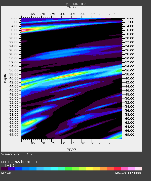
| Estimated Moho Depth: |
16.0 km |
| Estimated Crust Vp/Vs: |
1.60 |
| Assumed Crust Vp: |
6.426 km/s |
| Estimated Crust Vs: |
4.016 km/s |
| Estimated Crust Poisson's Ratio: |
0.18 |
|
| Radial Match: |
93.33407 % |
| Radial Bump: |
400 |
| Transverse Match: |
88.012634 % |
| Transverse Bump: |
400 |
| SOD ConfigId: |
11737051 |
| Insert Time: |
2019-04-27 00:26:38.051 +0000 |
| GWidth: |
2.5 |
| Max Bumps: |
400 |
| Tol: |
0.001 |
|

Signal To Noise
| Channel | StoN | STA | LTA |
| OK:CHOK: :HHZ:20170329T04:19:38.913984Z | 22.995584 | 4.5995725E-6 | 2.0001983E-7 |
| OK:CHOK: :HHN:20170329T04:19:38.913984Z | 8.077755 | 2.3777666E-6 | 2.9435984E-7 |
| OK:CHOK: :HHE:20170329T04:19:38.913984Z | 7.2138577 | 2.0209336E-6 | 2.8014603E-7 |
| Arrivals |
| Ps | 1.6 SECOND |
| PpPs | 6.2 SECOND |
| PsPs/PpSs | 7.7 SECOND |


