You are here: Home > Network List > OK - Oklahoma Seismic Network Stations List
> Station RLOK Rose Outlook, Oklahoma, USA > Earthquake Result Viewer
RLOK Rose Outlook, Oklahoma, USA - Earthquake Result Viewer
| Earthquake location: |
Near East Coast Of Kamchatka |
| Earthquake latitude/longitude: |
56.9/162.7 |
| Earthquake time(UTC): |
2017/03/29 (088) 04:09:24 GMT |
| Earthquake Depth: |
23 km |
| Earthquake Magnitude: |
6.6 Mww |
| Earthquake Catalog/Contributor: |
NEIC PDE/us |
|
| Network: |
OK Oklahoma Seismic Network |
| Station: |
RLOK Rose Outlook, Oklahoma, USA |
| Lat/Lon: |
36.17 N/95.03 W |
| Elevation: |
395 m |
|
| Distance: |
66.6 deg |
| Az: |
59.508 deg |
| Baz: |
324.27 deg |
| Ray Param: |
0.057486065 |
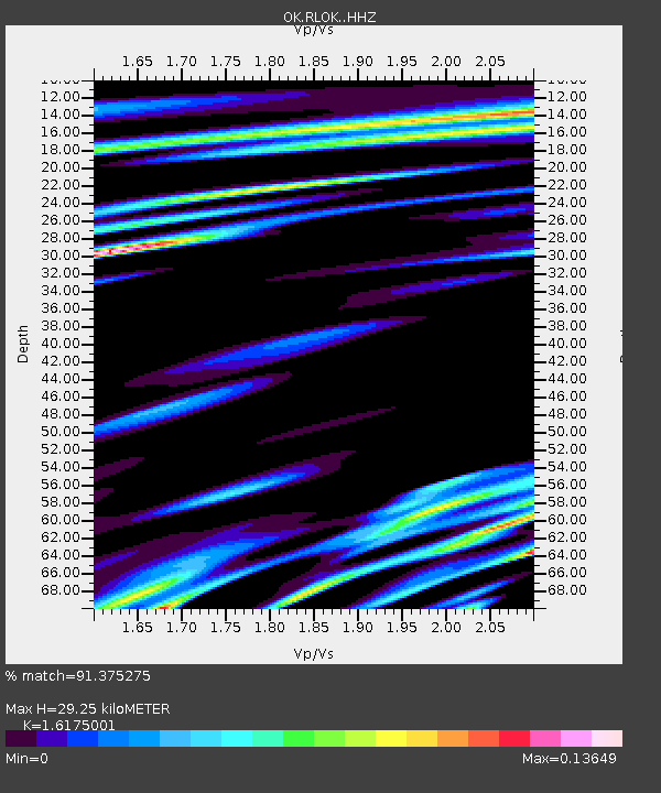
| Estimated Moho Depth: |
29.25 km |
| Estimated Crust Vp/Vs: |
1.62 |
| Assumed Crust Vp: |
6.53 km/s |
| Estimated Crust Vs: |
4.037 km/s |
| Estimated Crust Poisson's Ratio: |
0.19 |
|
| Radial Match: |
91.375275 % |
| Radial Bump: |
371 |
| Transverse Match: |
83.081436 % |
| Transverse Bump: |
400 |
| SOD ConfigId: |
11737051 |
| Insert Time: |
2019-04-27 00:26:45.416 +0000 |
| GWidth: |
2.5 |
| Max Bumps: |
400 |
| Tol: |
0.001 |
|

Signal To Noise
| Channel | StoN | STA | LTA |
| OK:RLOK: :HHZ:20170329T04:19:41.988997Z | 15.16251 | 4.891527E-6 | 3.2260667E-7 |
| OK:RLOK: :HHN:20170329T04:19:41.988997Z | 4.8581233 | 2.0818195E-6 | 4.285234E-7 |
| OK:RLOK: :HHE:20170329T04:19:41.988997Z | 4.516388 | 1.5747087E-6 | 3.486655E-7 |
| Arrivals |
| Ps | 2.9 SECOND |
| PpPs | 11 SECOND |
| PsPs/PpSs | 14 SECOND |


