You are here: Home > Network List > TA - USArray Transportable Network (new EarthScope stations) Stations List
> Station F04A Amboy, WA, USA > Earthquake Result Viewer
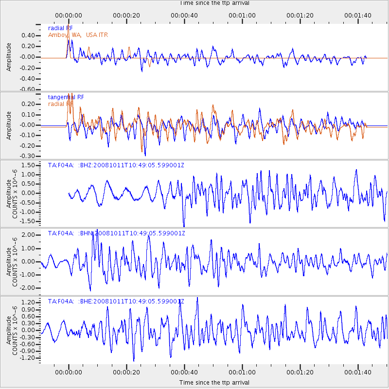
F04A Amboy, WA, USA - Earthquake Result Viewer
*The percent match for this event was below the threshold and hence no stack was calculated.
| Earthquake location: |
Virgin Islands |
| Earthquake latitude/longitude: |
19.2/-64.8 |
| Earthquake time(UTC): |
2008/10/11 (285) 10:40:14 GMT |
| Earthquake Depth: |
23 km |
| Earthquake Magnitude: |
6.1 MB, 5.9 MS, 6.1 MW, 6.0 MW |
| Earthquake Catalog/Contributor: |
WHDF/NEIC |
|
| Network: |
TA USArray Transportable Network (new EarthScope stations) |
| Station: |
F04A Amboy, WA, USA |
| Lat/Lon: |
45.93 N/122.42 W |
| Elevation: |
211 m |
|
| Distance: |
54.0 deg |
| Az: |
313.286 deg |
| Baz: |
99.615 deg |
| Ray Param: |
$rayparam |
*The percent match for this event was below the threshold and hence was not used in the summary stack. |
|
| Radial Match: |
70.77647 % |
| Radial Bump: |
400 |
| Transverse Match: |
61.720493 % |
| Transverse Bump: |
400 |
| SOD ConfigId: |
2560 |
| Insert Time: |
2010-03-05 22:41:55.598 +0000 |
| GWidth: |
2.5 |
| Max Bumps: |
400 |
| Tol: |
0.001 |
|
Signal To Noise
| Channel | StoN | STA | LTA |
| TA:F04A: :BHN:20081011T10:49:05.599001Z | 2.8886454 | 5.234149E-7 | 1.8119735E-7 |
| TA:F04A: :BHE:20081011T10:49:05.599001Z | 0.5363921 | 1.303778E-7 | 2.4306436E-7 |
| TA:F04A: :BHZ:20081011T10:49:05.599001Z | 1.3144248 | 3.968882E-7 | 3.0194818E-7 |
| Arrivals |
| Ps | |
| PpPs | |
| PsPs/PpSs | |


