You are here: Home > Network List > OV - Observatorio Vulcanolżgico y Sismolżgico de Costa Rica Stations List
> Station PLAN Los Planes de Bahía Drake , Puntarenas > Earthquake Result Viewer
PLAN Los Planes de Bahía Drake , Puntarenas - Earthquake Result Viewer
| Earthquake location: |
Near East Coast Of Kamchatka |
| Earthquake latitude/longitude: |
56.9/162.7 |
| Earthquake time(UTC): |
2017/03/29 (088) 04:09:24 GMT |
| Earthquake Depth: |
23 km |
| Earthquake Magnitude: |
6.6 Mww |
| Earthquake Catalog/Contributor: |
NEIC PDE/us |
|
| Network: |
OV Observatorio Vulcanolżgico y Sismolżgico de Costa Rica |
| Station: |
PLAN Los Planes de Bahía Drake , Puntarenas |
| Lat/Lon: |
8.67 N/83.68 W |
| Elevation: |
133 m |
|
| Distance: |
95.3 deg |
| Az: |
65.5 deg |
| Baz: |
329.689 deg |
| Ray Param: |
0.040821597 |
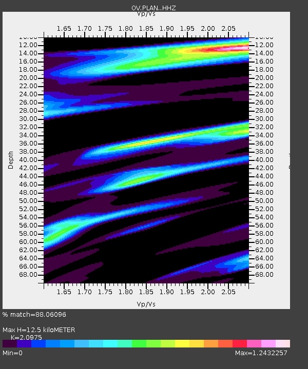
| Estimated Moho Depth: |
12.5 km |
| Estimated Crust Vp/Vs: |
2.10 |
| Assumed Crust Vp: |
6.436 km/s |
| Estimated Crust Vs: |
3.068 km/s |
| Estimated Crust Poisson's Ratio: |
0.35 |
|
| Radial Match: |
88.06096 % |
| Radial Bump: |
354 |
| Transverse Match: |
63.145008 % |
| Transverse Bump: |
400 |
| SOD ConfigId: |
11737051 |
| Insert Time: |
2019-04-27 00:27:08.028 +0000 |
| GWidth: |
2.5 |
| Max Bumps: |
400 |
| Tol: |
0.001 |
|

Signal To Noise
| Channel | StoN | STA | LTA |
| OV:PLAN: :HHZ:20170329T04:22:15.05998Z | 8.395865 | 1.2793339E-6 | 1.5237667E-7 |
| OV:PLAN: :HHN:20170329T04:22:15.05998Z | 2.261397 | 5.072251E-7 | 2.2429725E-7 |
| OV:PLAN: :HHE:20170329T04:22:15.05998Z | 1.2987977 | 3.3603143E-7 | 2.5872498E-7 |
| Arrivals |
| Ps | 2.2 SECOND |
| PpPs | 5.9 SECOND |
| PsPs/PpSs | 8.1 SECOND |


