You are here: Home > Network List > UU - University of Utah Regional Network Stations List
> Station VRUT Veyo Road, Veyo, UT, USA > Earthquake Result Viewer
VRUT Veyo Road, Veyo, UT, USA - Earthquake Result Viewer
| Earthquake location: |
Solomon Islands |
| Earthquake latitude/longitude: |
-8.9/158.4 |
| Earthquake time(UTC): |
2015/11/18 (322) 18:31:04 GMT |
| Earthquake Depth: |
11 km |
| Earthquake Magnitude: |
6.8 MWB, 7.0 MI |
| Earthquake Catalog/Contributor: |
NEIC PDE/NEIC COMCAT |
|
| Network: |
UU University of Utah Regional Network |
| Station: |
VRUT Veyo Road, Veyo, UT, USA |
| Lat/Lon: |
37.46 N/113.86 W |
| Elevation: |
1874 m |
|
| Distance: |
93.6 deg |
| Az: |
52.811 deg |
| Baz: |
261.547 deg |
| Ray Param: |
0.041233588 |
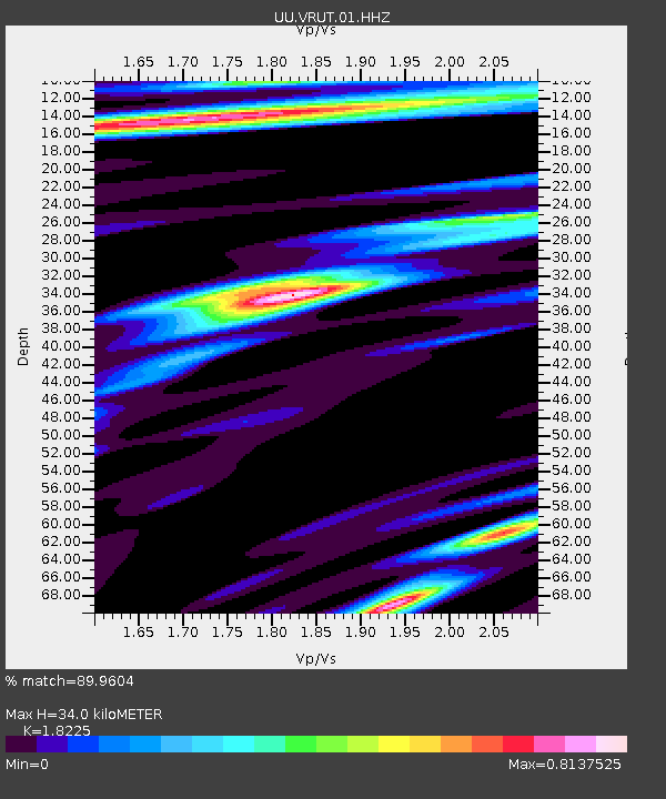
| Estimated Moho Depth: |
34.0 km |
| Estimated Crust Vp/Vs: |
1.82 |
| Assumed Crust Vp: |
6.194 km/s |
| Estimated Crust Vs: |
3.399 km/s |
| Estimated Crust Poisson's Ratio: |
0.28 |
|
| Radial Match: |
89.9604 % |
| Radial Bump: |
400 |
| Transverse Match: |
72.421165 % |
| Transverse Bump: |
400 |
| SOD ConfigId: |
1259291 |
| Insert Time: |
2015-12-02 19:22:52.970 +0000 |
| GWidth: |
2.5 |
| Max Bumps: |
400 |
| Tol: |
0.001 |
|

Signal To Noise
| Channel | StoN | STA | LTA |
| UU:VRUT:01:HHZ:20151118T18:43:48.659976Z | 3.4390485 | 1.5824169E-8 | 4.6013215E-9 |
| UU:VRUT:01:HHN:20151118T18:43:48.659976Z | 1.4367983 | 6.4808954E-9 | 4.5106505E-9 |
| UU:VRUT:01:HHE:20151118T18:43:48.659976Z | 0.7234555 | 4.9164464E-9 | 6.795783E-9 |
| Arrivals |
| Ps | 4.6 SECOND |
| PpPs | 15 SECOND |
| PsPs/PpSs | 20 SECOND |


